
Yesterday saw a transition from a muggy morning to a more comfortable evening, setting up a forecast today that will be nothing short of exceptional when it comes tosummer weather.

High pressure will keep Boston shining bright with sunny skies as relatively cooler and dry air sinks to the surface today. And we won’t see the kind of heat up that defined days earlier this week. Temperatures across Boston will settle near an average of 83 degrees, in part due to the cooler northwesterly flow.
The dry air will be noticeable as you head out the door. Today will likely be the first time since July 3 (more than two weeks) where the average dew point for the day will be below 60 degrees in the city.

In fact, the dew points across the area are expected to stay comfortable through the weekend and possibly into early next week, before the pattern changes back towards a muggy setup.
Advertisement

With the sun still setting past 8:15 p.m., it will be a lovely night to enjoy a walk around the neighborhood or dinner outdoors. Sleeping temperatures will drop down into the mid 60s, so open up some windows and let the fresh air in.

Weekend Breakdown
Yes, this weekend will shape up to be one of the best so far this summer. Temperatures across Boston for both Saturday and Sunday should range between the mid and upper 80s, but the dry air will make the afternoon highs much more tolerable than they have been. Dew points should remain close to 60 degrees for both Saturday and Sunday — which means daytime heat can actually escape the atmosphere when the sun goes down instead of being trapped in moist surface air. Expected Saturday and Sunday nights to remain mostly refreshing with overnight lows in the mid and upper 60s.
The one caveat that may play spoiler is another high pressure system that is racing towards New England behind the current one. It could spark a brief shower or two Saturday afternoon across the region — but there’s a good chance those spot showers will stay away from Boston, keeping the city dry throughout the weekend.
Advertisement
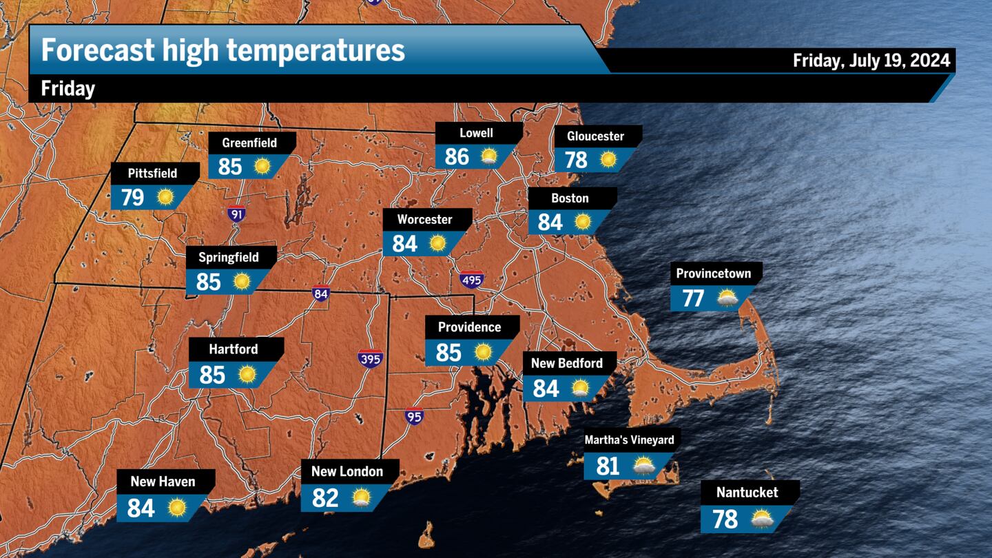
Friday Breakdown
Southern New England: Beautiful day with sunny skies and a slight breeze from the northwest. Dry air will make the day feel even more comfortable. There may be a few clouds that build up around sunset, but the area will otherwise stay dry to start off the weekend.
Western Mass: A comfortable day is expected with lots of sunshine and temperatures reaching the mid 80s across the Pioneer Valley and around 80 across the Berkshires. An afternoon breeze to five miles per hour will hardly be noticeable on an otherwise ideal summer day.
Cape and the Islands: A few morning clouds will give way to mostly sunny skies early. Today’s highs should near 80, but a few communities will likely stay in the upper 70s. A great place to be if you have the day off, just remember the sunscreen if you’re headed to the beach.
Northern New England: Beautiful and comfortable with temperatures ranging from the upper 70s into the low 80s. Mostly sunny skies with a small northwesterly breeze to about seven miles per hour. A great day to be outdoors.

Ken Mahan can be reached at [email protected]. Follow him on Instagram @kenmahantheweatherman.