Binghamton, NY
Weather Forecast Office
Latest aviation discussion:
.AVIATION /12Z TUESDAY THROUGH SATURDAY/...
Valley fog has lifted from AVP and will lift from ELM between
now and 1230Z. Otherwise, VFR conditions will persist for the
morning hours.

Timing of thunderstorms today is coming into sharper focus, with
remnants of an MCS likely playing a key role. Generally carried
3-hour TEMPO groups as early as 18Z and ending as late as 22Z.
Organized thunderstorms may pass north of AVP this time around,
and with the uncertainty, left out TEMPOs at AVP.

Areas of MVFR ceilings may develop late tonight/early Wed
morning across the area.


Outlook...

Wednesday...Restrictions possible in showers and thunderstorms.

Thursday through Saturday...Mainly VFR.
|
This discussion and more can be found in the Area Forecast Discussion.
Aviation Forecasts
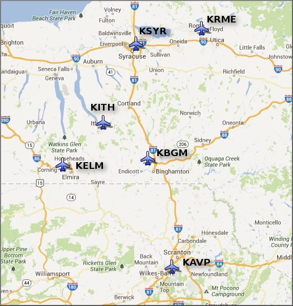
The National Weather Service Office in Binghamton, NY has responsibility for six Terminal Aerodrome Forecasts or TAFs in Central New York and Northeast Pennsylvania.
Click on a site on the map below to view the latest TAF.
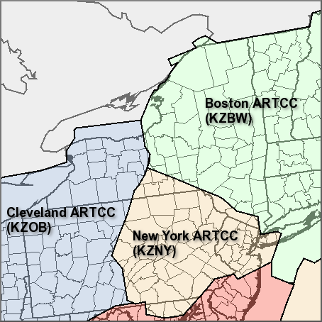
Center Weather Service Unit Products
Three Center Weather Service Unit (CWSU) cover the NWS Binghamton, NY County Warning Area. Click on the map or one of the links below the map to go to the corresponding CSWU website.
Text links...
Decoded/Raw Text
| Location | Sky/Weather | Temperature | Dewpoint Temperature | Relative Humidity | Wind | Pressure | Remarks |
| Binghamton, NY | MOSUNNY | 66 | 64 | 93 | CALM | 29.85S | |
| Cortland, NY | CLOUDY | 63 | 63 | 100 | CALM | 29.83F | FOG |
| Dansville, NY | PTSUNNY | 69 | 64 | 84 | SE12 | 29.79F | |
| Elmira, NY | FOG | 66 | 65 | 96 | CALM | 29.82F | VSB<1/4 |
| Ithaca, NY | MOSUNNY | 66 | 64 | 93 | SE5 | 29.84S | |
| Monticello, NY | NOT AVBL | ||||||
| Penn Yan, NY | PTSUNNY | 68 | 65 | 90 | SW8 | 29.80F | |
| Rome, NY | CLOUDY | 71 | 70 | 96 | E5 | 29.80F | |
| Syracuse, NY | PTSUNNY | 73 | 67 | 81 | SE5 | 29.79S | |
| Hazleton, PA | N/A | 68 | 68 | 100 | CALM | 29.93R | |
| Scranton, PA | SUNNY | 68 | 65 | 90 | SE3 | 29.88R | |
| 700 AM EDT TUE JUL 16 2024 | |||||||
METAR Request form via the Aviation Weather Center. Raw and decoded observations.
​Surface Weather Maps
Miscellaneous
Current Hazards
Briefing
Drought
Fire Weather
Graphical Hazardous Weather Outlook
Hurricanes
Local Outlook
River Flooding
Space Weather
Thunderstorms
Winter
Current Conditions
Air Quality
Local Storm Reports
Observation (list)
Observations (Map)
More Surface Observations
Rainfall
Satellite
More Satellite
Upper Air
Radar
Local Enhanced Radar
Local Standard Radar (low bandwidth)
Regional/National Standard Radar (low bandwidth)
More Radar
Forecasts
Activity Planner
Aviation
Detailed View
Fire Weather
Forecaster's Discussion
Hourly View
Map View
Model Data
Space Weather
Text Products
User Defined Area Forecast
Rivers and Lakes
River Forecasts (Map)
River Observations (Map)
River Forecast Centers
River Forecasts (Text)
Ensemble River Guidance
Current Streamflow
Flood Inundation Maps
River Monitor
US Dept of Commerce
National Oceanic and Atmospheric Administration
National Weather Service
Binghamton, NY
32 Dawes Drive
Johnson City, NY 13790
(607) 729-1597
Comments? Questions? Please Contact Us.

