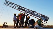
How an Architect Redesigns NYC Streets
Released on 04/22/2022
[Claire] In 2016, this was a very confusing place to be.
Designing streets is a little bit like being a detective.
If you look hard enough, you can see the traces
of all the decisions people made before.
[Narrator] Claire is the principal in charge of WXY
an architecture firm with a focus on urban design,
planning and community based architecture.
I'm gonna walk you through three street redesigns
that WXY has done in New York city.
[soft music]
Sometimes you hear the term bad street.
There's no vegetation, there's nothing to look at,
there's nothing to visit.
Generally people will go, Oh my God, that's not a street
I wanna walk down.
And therefore, it's not a great street.
And the opportunity as an architect or landscape architect
or urban designer, is to kind of see what's happening
really listen and observe
because there needs to be design solutions to the problems
that people are experiencing on their streets.
Let's, let's talk about Cooper Union.
[Narrator] Cooper union is an intersection in New York
where Bowery splits off into Cooper Square.
[Claire] The original street only did this.
[Narrator] The Bowery was widen,
and there were too many lanes for cars
and not enough crosswalks for pedestrians.
It's really interesting is that departments
of transportation were actually departments of cars
for a long time.
And mostly they would describe streets
by the number of lanes.
[Narrator] The street ultimately expanded
to four lanes of traffic
which resulted in a very confusing intersection.
[Claire] We're seeing everything being two ways,
two moving lanes in every direction,
but confusion in the middle, and here's our sidewalk.
That is a lot of road bed,
because if I was looking at just doting in, you know,
what a street would be, right?
I'm left with a kind of no-man zone here.
[Narrator] For pedestrians,
there's no clear way to cross the intersection.
So the way people have tried to deal with it
is where you see all sorts of painted medians
all over the place,
to try and kind of tell people what they should be doing.
[Narrator] And it was completely car focused
which didn't add much to the character of the street.
[Claire] The bigger you make roads,
the more it attracts traffic.
But it doesn't really attract things like business,
more cyclists, more walking.
In a lot of ways it's an kind of a human behavior issue.
[Narrator] The solution, reduce the number of lanes,
add pedestrian crosswalks,
and limit the direction of traffic.
Instead of a bunch of streets,
you have a very straightforward way for cars even
which they could not do before,
to drive up this street which is now one way,
and what's that's done, is it's made more sidewalks
and that's really fundamentally
what you're seeing with street design,
is a way to make streets still serve cars efficiently
but also make it easier for people on buses, people biking,
all of these kinds of lanes
can kind of shift priorities and give new spaces.
[Narrator] Now let's head to Brooklyn
to take a look at Albee Square.
Albee Square is an intersection in downtown Brooklyn
where Fleet, Fulton Street,
Albee Square West and Bond Street, all meet up.
[Claire] But many of the subways are sort of
off to the corner on very narrow sidewalks.
[Narrator] This area has a lot of pedestrian traffic,
but not a lot of space to maneuver
especially since these are small historical streets.
[Claire] When you have historic streets,
they're not always as wide as connector streets
that got cleared out because people but wanted more lanes.
So, a lot of the planning that's happening
around Albee Square in these remnants
of different grids that make up downtown Brooklyn
and all the new buildings, is to create more room.
What do we see on the right hand side?
Well, all of a sudden this street right here
isn't there anymore.
But now this street meets,
we have a much larger public space.
Instead of an island surrounded by streets,
we have an island that's now attached
to the sidewalk for a beautiful bank building
and a new mall called Albee Square Mall,
that's full of activity.
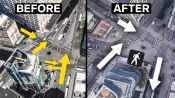
[Narrator] Next up is Astor Place.
We're at pretty well known destination in New York
called Astor place.
[Narrator] Astor place is an intersection
where Lafayette, Eighth Street, Fourth Avenue
and Cooper square, all converge.
These are streets that are doing a lot of work.
In 2016, this was a very confusing place to be.
Wide streets, narrow streets,
there's a lot of buses hanging out waiting.
So, people just walked in the street.
That's the subway.
And there's a number of kind of geometries of streets,
all cutting through it.
That is called the Alamo
that people of nicknamed The Cube.
You see people hang out underneath it.
The cube is kind of sitting on also
kind of a floating concrete median,
and then we have a street here known as Lafayette Street
that is going uptown.
[Narrator] In addition to these main streets,
Astor Place has a number of a historical streets,
all feeding into the traffic flow.
This where I'm drawing this dotted line
is one of the oldest streets in New York.
And it got renamed Stuyvesant Street.
This street must have started as a dirt path.
And in fact, a lot of streets in New York,
Center Street, Lafayette, Broadway were actually just rails.
And then they got widened, they got paved.
[Narrator] These multifunctional streets,
home to art installation, subway stops
and historical remnants of old New York
are prone to the wear and tear of high traffic areas.
[Claire] This is not a low space,
but there's a lot of flooding that happens
if rain comes really really quickly.
What you see now today, not only is there more trees
but there's actually bioswales and green infrastructure,
there's more bike racks, there's bigger sidewalks,
you have a huge number of additional green spaces and trees.
There's something called the curb line.
And the art I think of street making
is figuring out where the curb goes
so that all the buildings look and feel even better.
If you put the curb too close to a building
or in the wrong alignment, the whole street feels off.
So it's sort of like a great room or how clothes fit,
where the curb is, is kind of like the tailoring of streets.
We can start thinking about streets,
kind of like air and water as the thing that we share.
There are private streets,
but in general successful important streets
are shared by just a multiplicity of players, right?
And even by walking.
So streets in a sense are the design problem of today
to accommodate getting more out of them
and making them attractive to people,
but they're also the design problem of the near for future.
[soft music]

How the Disco Clam Uses Light to Fight Super-Strong Predators

Architect Explains How Homes Could be 3D Printed on Mars and Earth

Scientist Explains How Rare Genetics Allow Some to Sleep Only 4 Hours a Night

Scientist Explains Unsinkable Metal That Could Prevent Disasters at Sea

Is Invisibility Possible? An Inventor and a Physicist Explain

Scientist Explains Why Her Lab Taught Rats to Drive Tiny Cars

Mycologist Explains How a Slime Mold Can Solve Mazes

How the Two-Hour Marathon Limit Was Broken

Research Suggests Cats Like Their Owners as Much as Dogs

Researcher Explains Deepfake Videos

Scientist Explains How to Study the Metabolism of Ultra High Flying Geese

Hurricane Hunter Explains How They Track and Predict Hurricanes

Scientist Explains Viral Fish Cannon Video

A Biohacker Explains Why He Turned His Leg Into a Hotspot

Scientist Explains What Water Pooling in Kilauea's Volcanic Crater Means

Bill Nye Explains the Science Behind Solar Sailing

Vision Scientist Explains Why These Praying Mantises Are Wearing 3D Glasses

Why Some Cities Are Banning Facial Recognition Technology

Scientist's Map Explains Climate Change

Scientist Explains How Moon Mining Would Work

Scientist Explains How She Captured Rare Footage of a Giant Squid

Doctor Explains How Sunscreen Affects Your Body

Stranger Things is Getting a New Mall! But Today Malls Are Dying. What Happened?

The Limits of Human Endurance Might Be Our Guts
Meet the First College Students to Launch a Rocket Into Space

Scientist Explains Why Dogs Can Smell Better Than Robots

A Harvard Professor Explains What the Avengers Can Teach Us About Philosophy

NASA Twin Study: How Space Changes Our Bodies

What the Black Hole Picture Means for Researchers

Scientist Explains How to Levitate Objects With Sound

Why Scientists and Artists Want The Blackest Substances on Earth

Biologist Explains How Drones Catching Whale "Snot" Helps Research

Researcher Explains Why Humans Can't Spot Real-Life Deepfake Masks

Doctor Explains What You Need to Know About The Coronavirus

VFX Artist Breaks Down This Year's Best Visual Effects Nominees

How Doctors on Earth Treated a Blood Clot in Space

Scientist Explains Why Some Cats Eat Human Corpses

Voting Expert Explains How Voting Technology Will Impact the 2020 Election

Doctor Explains What You Need to Know About Pandemics

ER Doctor Explains How They're Handling Covid-19

Why This Taste Map Is Wrong

Q&A: What's Next for the Coronavirus Pandemic?

Why Captive Tigers Can’t Be Reintroduced to the Wild

How Covid-19 Immunity Compares to Other Diseases

5 Mistakes to Avoid as We Try to Stop Covid-19

How This Emergency Ventilator Could Keep Covid-19 Patients Alive

Why NASA Made a Helicopter for Mars

Theoretical Physicist Breaks Down the Marvel Multiverse

Former NASA Astronaut Explains Jeff Bezos's Space Flight

Physics Student Breaks Down Gymnastics Physics

What Do Cities Look Like Under a Microscope?

Inside the Largest Bitcoin Mine in The U.S.

How Caffeine Has Fueled History

How Mushroom Time-Lapses Are Filmed

Why You’ll Fail the Milk Crate Challenge

Why Vegan Cheese Doesn't Melt

How 250 Cameras Filmed Neill Blomkamp's Demonic

How Meme Detectives Stop NFT Fraud

How Disney Designed a Robotic Spider-Man

How Online Conspiracy Groups Compare to Cults

Dune Costume Designers Break Down Dune’s Stillsuits

Korean Phrases You Missed in 'Squid Game'

Why Scientists Are Stress Testing Tardigrades

Every Prototype that Led to a Realistic Prosthetic Arm

Why the Toilet Needs an Upgrade

How Animals Are Evolving Because of Climate Change

How Stop-Motion Movies Are Animated at Aardman

Astronomer Explains How NASA Detects Asteroids

Are We Living In A Simulation?

Inside the Journey of a Shipping Container (And Why the Supply Chain Is So Backed Up)

The Science of Slow Aging

How Nose Swabs Detect New Covid-19 Strains

Samsung S22 Ultra Explained in 3 Minutes

The Science Behind Elon Musk’s Neuralink Brain Chip

Every Prototype to Make a Humanoid Robot

Chemist Breaks Down How At-Home Covid Tests Work

A Timeline of Russian Cyberattacks on Ukraine

VFX Artist Breaks Down Oscar-Nominated CGI

Why Smartphone Night Photos Are So Good Now

We Invented the Perfect WIRED Autocomplete Glue

How Everything Everywhere All at Once's Visual Effects Were Made

How Dogs Coevolved with Humans
How an Architect Redesigns NYC Streets

Viking Expert Breaks Down The Northman Weapons

J. Kenji López-Alt Breaks Down the Science of Stir-Fry

How A.I. Is Changing Hollywood

How Trash Goes From Garbage Cans to Landfills

Veterinarian Explains How to Prevent Pet Separation Anxiety
The Science Behind Genetically Modified Mosquitoes

How Scientists & Filmmakers Brought Prehistoric Planet's Dinosaurs to Life

All the Ways Google Gets Street View Images

How Public Cameras Recognize and Track You

How the Nuro Robotic Delivery Car Was Built

Biologist Explains the Unexpected Origins of Feathers in Fashion

Surgeons Break Down Separating Conjoined Twins

Former Air Force Pilot Breaks Down UFO Footage

Bug Expert Explains Why Cicadas Are So Loud

The Best of CES 2021

Health Expert Explains What You Need to Know About Quarantines

Scientist Explains How People Might Hibernate Like Bears

Could a Chernobyl Level Nuclear Disaster Happen in the US?

Neuroscientist Explains ASMR's Effects on the Brain & The Body

Why Top Scientists Are Pretending an Asteroid is Headed for Earth

Epidemiologist Answers Common Monkeypox Questions

Bill Nye Breaks Down Webb Telescope Space Images

How This Humanoid Robot Diver Was Designed

Every Trick a Pro GeoGuessr Player Uses to Win

How NASA Biologists Plan to Grow Plants on the Moon

How FIFA Graphics & Gameplay Are Evolving (1993 - 2023)

How a Vet Performs Dangerous Surgeries on Wild Animals
This Heart is Not Human

How Entomologists Use Insects to Solve Crimes

Former NASA Astronaut Breaks Down a Rocket Launch

Chess Pro Explains How to Spot Cheaters

Why Billionaires Are Actually Ruining the Economy

How to Keep Your New Year’s Resolutions for More Than a Week

The Biology Behind The Last of Us

English Teacher Grades Homework By ChatGPT

All the Ways a Cold Plunge Affects the Body

Spy Historian Debunks Chinese Spy Balloon Theories

A.I. Tries 20 Jobs | WIRED

Mathematician Breaks Down the Best Ways to Win the Lottery

Why Music Festivals Sound Better Than Ever

Pro Interpreters vs. AI Challenge: Who Translates Faster and Better?

Why The Average Human Couldn't Drive An F1 Car

Atomic Expert Explains "Oppenheimer" Bomb Scenes
Every 'Useless' Body Part Explained From Head to Toe

How Pilots and Scientists Are Thinking About the Future of Air Travel

How To Max Out At Every Fantasy Football Position (Ft. Matthew Berry)

All The Ways Mt. Everest Can Kill You

How Fat Bears Bulk Up To Hibernate (And Why We Love To See It)

Why Vintage Tech Is So Valuable To Collectors
8 Photos That Tell The History of Humans In Space

How Every Organ in Your Body Ages From Head to Toe

Why AI Chess Bots Are Virtually Unbeatable (ft. GothamChess)
How Mind-Controlled Bionic Arms Fuse To The Body

Historian Breaks Down Napoleon's Battle Tactics


