Home & Garden
Rain, Thunderstorms and Even Snow All in Manchester's Forecast
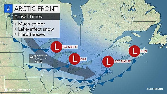
Today will be the last great weather day for awhile before rain and thunderstorms, fog, wind, an arctic blast and some snow all move in.

Savor today, it’s looking to be the best weather day for what may seem like a long, long time.
Today, is a picture perfect spring day, sunshine and temps in the mid to upper 60s and 70s are possible.
And then around midnight Mother Nature seemingly flips a switch on us and we’re dealing with spring’s showers, gusty winds and thunderstorms and then possibly snow, yes there a couple of snow chances in the forecast.
NBC Connecticut Meteorologist Ryan Hanrahan said, “A strong upper level disturbance is going to swing through Saturday night and it could produce a heavy round of snow squalls - especially after midnight in the wee hours of Sunday morning. Something to watch if you have plans late Saturday night.”
WTNH News 8 Meteorologist Gil Simmons says, “Mild temperatures today with 60s in the forecast. It will be windy at times with gusts to 45 mph today. Rain showers in the forecast for Friday followed by a rude cold wind on Sunday and a few snow showers too!”
Here are the latest details on wild and always unpredictable weather via the National Weather Service:
Today: Sunshine, temps approaching 70 degrees.
Thursday night and Friday: Showers develop after midnight and there is a chance of showers and thunderstorms through the day on Friday and Friday night.
We could see winds gusting to 25 mph on Friday, and fog as well. Because it’s not expected to be a soaking consistent rain, the total rain accumulation is expected to be less than an inch for the entire duration. The exception is if you’re in the path of a thunderstorm.
Saturday: Rain ends early and then it’s cloudy with temps in the low to mid 50s.
Saturday night: Showers are possible on the immediate Connecticut coastline, while snow showers are possible inland as it will be cold enough.
Sunday: Temps crash and only approach the low 40s. Snow showers are possible for inland and interior sections of Connecticut early on Sunday.
Monday: Continued cold weather, with plain rain forecast on the immediate Connecticut coastline and a mix of rain and snow showers for inland and northern sections of the state.
Monday night and Tuesday: The coastline may see a mix of snow and rain but interior sections may see all snow late Monday into Tuesday. No one has predicted whether any of this snow may accumulate though.
Hazardous Weather Outlook Issued for Fairfield, New Haven, Middlesex, and New London counties for Saturday night, but not for snow, it’s for the wind.
On Saturday night, wind gusts for southern Connecticut may reach 60 mph which could lead to power outages, the National Weather Service predicts. Temps will also be below freezing Sunday night and sensitive vegetation could be killed if left outdoors.
Photo credit: Accuweather.com
Get more local news delivered straight to your inbox. Sign up for free Patch newsletters and alerts.