
Frequently Asked Questions
Adopt a Storm Drain
Waste:
- Pick up and dispose of pet waste properly.
- Do not leave bagged poop on trails. During rain events it will flow directly to nearest waterway.
- Do not put leaves, cut grass, and other yard waste in or near storms drains.
Vehicles:
- Fix vehicle leaks
- Dispose of used motor oil and other car fluids at your local service station or the Household Hazardous Waste Facility (512)974 -4343
- Wash your vehicle where soap and water flows into grass, not the street, or use a carwash.
Lawns:
- Use fewer fertilizers, pesticides, and weed killers in your yard
- Plant native plants that will not need as much water and fertilizers.
Trash:
Start a fun habit of picking up 3 pieces of trash per day. 75% of trash in waterways came from land. Large trash can block storm drains causing flooding. For removal of bulky trash call 3-1-1.
- Storm Drain Marking Volunteer Program
- Scoop the Poop Education
- Adopt A Creek https://keepaustinbeautiful.org/programs/adopt-a-creek/
- Sign up to receive a once a month email about volunteer opportunities in building Rainscapes, Grow Zones, Invasive Plants removal, and/or collecting aquatic macroinvertebrates here
- Report Pollution and Dumping to our Pollution Prevention Hotline (512)974-2550
Available anytime 24 hours a day 7 days a week
Austin Invasive Plants Management
The Austin City Council passed a resolution on April 8, 2010 directing the City Manager to develop an Invasive Species Management Plan to guide efforts to minimize the harmful environmental and economic impacts of invasive plant species on city-managed properties. Subsequent to that resolution an agreement with the Lady Bird Johnson Wildflower Center led to creation of a working group with representatives from several City departments, Austin Parks Foundation, Keep Austin Beautiful, Texas Parks and Wildlife and the Austin Invasive Species Coalition. Over the course of ten consensus-based meetings, the Working Group developed strategic five-year goals based on a central framework of prevention, early detection-rapid response and long-term control at prioritized sites. The plan also includes recommendations for implementation including staffing, funding sources, centralized mapping and monitoring, and education and outreach. To improve the plan’s success, the working group has developed a preliminary list of priority invasive species and an invasive species resource manual with identification fact sheets and best management practices to control priority species.
The City of Austin Invasive Species Management Plan was developed in collaboration with multiple non-profits and departments.
Austin Energy
Austin Invasive Species Coalition – represented by American Youthworks Environmental Corps
Austin Parks Foundation
Austin Water Utility
Keep Austin Beautiful
Lady Bird Johnson Wildflower Center
Parks and Recreation Department
Planning and Development Review
Texas Parks & Wildlife
Watershed Protection Department
When a species ends up in a new ecosystem, it is considered "introduced". Often, invasive species are spread by humans who do not realize that these plants, animals and insects are highly destructive.
This may happen, for example, when people plant garden ornamentals, range forage plants for cattle, or plants used for erosion control and habitat enhancement for wildlife. This can also occur when animals and insects are introduced to be used to control other organisms (particularly in agriculture).
Other species are introduced accidentally on imported nursery stock, fruits, and in ship ballast waters, on vehicles, in packing materials and shipping containers, through human-built canals, and from human travel. Dumping aquarium exotic fish and unwanted exotics into the water or wild are other common ways invasive species spread.
Austin Lakes Index
All three lakes are manmade reservoirs, Lady Bird and Lake Austin are flow-through reservoirs on the Colorado River, and Lake Long is a cooling reservoir for the Decker Creek Power Station.
Lady Bird 471 surface acres, 5 miles long Created in 1960 as an impoundment of the Colorado River with the completion of Longhorn Dam Originally named Town Lake, renamed Lady Bird Lake in 2007 to honor Lady Bird Johnson Operation and flow Flow-through reservoir (little storage capacity), typically has two ‘seasons’
- Mar-Oct has higher flows, more river-like as LCRA passes water through to downstream rice farmers
- Oct- Mar has lower flows, more lake-like as water is stored in Lake Travis for use during irrigation season
Beginning in 2012, the flows became less variable, as LCRA has restricted irrigation releases during the historic drought.
Reservoir uses
Lady Bird used to be a source of public drinking water and also was a cooling reservoir for the now-decommissioned Holly Power Plant (Future: Holly Shores project) Currently, the lake is primarily used for non-motorized recreation (canoeing, kayaking, competitive rowing, paddleboarding) as well as providing refuge for a wide variety of birds and urban wildlife. It is also a great spot for fishing, whether from the shore or on the water (gas motors on your boat! Check out TPWD’s web for more details Lady Bird’s Hike and Bike Trail.
Lady Bird's Hike and Bike Trail is an important recreational ‘get away’ for both Austinites and visitors.
Lake Austin
1600 surface acres 21 miles long Created in 1940 as an impoundment of the Colorado River with the completion of Tom Miller Dam Operation and flow Flow-through reservoir with little storage capacity, typically has two ‘seasons’:
- Mar-Oct has higher flows, more river-like as LCRA passes water through to downstream rice farmers
- Oct- Mar has lower flows, more lake-like as water is stored in Lake Travis for use during irrigation season In 2012, the flows became less variable, as LCRA has restricted irrigation releases during the historic drought.
Reservoir uses
Current uses include generation of hydroelectric power at upper (Mansfield) and lower (Tom Miller) dams, conveyance of flood and irrigation water, multiple public and private drinking water intakes, including two owned by City of Austin (Ullrich and Davis Water Treatment Plants). Several parks and public boat ramps provide public access, check this link for more information.
Important recreation destination for water sports and sport fishing, with trophy sized large mouth bass. For more information on fishing Lake Austin, check TPWD’s webpage.
Lake Walter E. Long 1,269 surface acres Created in 1967 as a cooling reservoir for Decker Creek Power Station, it impounds Decker Creek. City of Austin owns the lake and entire shoreline Public access (park and boat ramp) on the southeast shore, click here for more details Insert link to PARD Lake Long site: http://www.austintexas.gov/page/lake-walter-e-long
Important recreational resource, Walter E. Long Park (link) with healthy sport fish communities. . For more information about fishing at Lake Long, check TPWD’s webpage.
Operations and flow: Up to 680 million gallons of water per day is pulled in from the Colorado River to the southwestern arm of the reservoir and used as cooling water for the power plant. This warmer water is discharged into the northeast arm, losing heat as it flows through the reservoir, back to the southwest area. The lake level is maintained by pumping water from the Colorado River at an average rate of 16,156 acre feet/year. Austin Energy then releases 500 gallons per day to maintain flow through the lake and in Decker Creek downstream of the lake. Lake water quality: This river water is high in nutrients, and this combines with the warm water from the power plant to limit the lake’s water quality, regardless of the healthy riparian zone provided by the preserve and parkland along its shores. The increased nutrients, warmer water temps and longer retention time often leave the lake vulnerable to algal blooms through out the year.
Austin's Reservoir Resource
The logs you see on the shoreline are made of “Coir” and have been placed with plantings for erosion control and lakeshore habitat.
Coir is the natural fiber found in ripe coconut husks, and it has been used for centuries to make ship ropes due to its durability and resistance to water damage. One of the modern uses for coir includes mats or logs of coir fiber bound by coir ropes for erosion control. Coir is anchored in areas with loose soils that need stabilization including stream banks, wetlands and construction sites. The advantage of using coir logs for erosion control (rather than rocks or bulkheads) is that the coir allows vegetation to grow within it as it slowly biodegrades becoming part of the matrix of the soil. When the coir has finally biodegraded (years later), the roots of the vegetation then provide the long-term stability of the soil which provides natural and beneficial integrity to the land and water.
Although appealing in its low cost, durability and ability to biodegrade, it was unclear if coir logs would be successful in stabilizing the shoreline of Lake Austin due to the intense wave energy from recreational boating. A pilot study to test this method in Lake Austin was initiated in Summer 2009. After 5 years of observation, it was determined that coir logs and plants can be successful (under certain circumstances) in stabilizing and restoring a shoreline to a more natural state. Most coir logs deteriorated slowly and the remaining fiber has roots and stems growing throughout. The pilot study provided valuable information regarding placement, location, timing and plant species.
The Watershed Protection Department has recently installed an additional ~2,000 feet of coir logs and plantings along shorelines managed by the City and County. The sites are currently greatly impacted by erosion and the effort may slow down erosion long enough to develop a resilient vegetation community benefiting both stability, habitat and water quality.

An eroding bank of Lake Austin

Newly placed coir logs and plantings along shoreline

Coir logs and plantings 4 years after installment
Ecosystem services, stated simply, are the benefits humans derive from the environment. Food, clean air and water, fiber for clothes….these are obvious and significant examples of supplies upon which we are dependent. What keeps the water and air clean? How can the land keep providing food to feed billions of people? Why am I happier when out in ‘nature’? Is my home worth more because of its proximity to a resource (e.g., lake, river, park, forest)?
Turns out, the environment is providing more for us then we tend to think about. The myriad processes that occur ‘outside’ give rise to the services we need and desire. Scientists have grouped the activities and products of nature into four categories: First, Provisioning Services. These are the services we are most familiar with (and grateful for) such as food, potable water, wood and fiber, and fuel. Then, we have the Regulating Services. These occur on a scale that may be imperceptible, when things are good, but relate to services very important to us including flood regulation, water purification and quantity, and disease regulation (think Ebola). Those services are still pretty tangible (and relatively easy to monetize). Services for which we have an innate desire are the Cultural Services. These include having a spiritual connection to nature, enjoying the aesthetic quality of the environment, and of course recreational activities (boating, hiking, camping, etc). Probably the most overlooked but important of all the Ecosystem Services provided by nature are what are known as the Supporting Services. The supporting services are the processes and functions of nature that give rise to all the other services listed above. We desire breathable air, plentiful food, and fiber, so we plant trees and shrubs that take up carbon dioxide and provide raw materials and fruits for consumption. Nutrient cycling mediated by plants and microbes help keep our water clean, our food nutritious (high in nutrients and other compounds), and slow climate change. A diverse, species rich landscape full of animals and plants gives us a sense of peace and fulfillment. Without nature and the environment doing what it does through the Supporting Services, we would not have the other services of interest. It is for the protection and sustainability of the environment that the Supporting services are so often studied by scientists and at heart, our regulations and protections are in place (e.g., minimizing nutrient pollution, deforestation, impervious cover). As human populations increase, our footprint on the landscape grows, and our need for ‘natural capital’ becomes greater to support mankind, it will be the protection, regulation, and protection of the Supporting Services that will ensure sustainability of all Ecosystem Services required and desired for the wellbeing of mankind.
The Austin reservoirs are in a constant state of flux. Natural and anthropogenic forces influencing the chemical, biological, and physical characteristics of Lake Austin and Lady Bird Lake include: altered flow regimes dictated by water availability, increased development, and introductions and control of species. Each reservoir is cherished for their aesthetic, recreational, commercial, and municipal benefits. In order to balance the needs of such different users while sustaining an ecologically desirable ecosystem, it is essential to understand the relationship between water chemistry and biological structure of the reservoirs.
One of the most important aspects of reservoir ecosystems influenced by the chemical and biological composition of the system is the flow of energy from primary producers to top consumers. Knowledge of the components of the food web (sources; e.g., aquatic vegetation, phytoplankton) supporting species of interest (consumers; e.g., largemouth bass) is necessary in order to make predictions of potential shifts in community structure that may result from environmental changes and for the implementation of adaptive management strategies ensuring sustainability of desired biological communities. This project aims to collect water and a myriad of potential sources and terminal consumers for measurement of 13C and 15N isotopic signatures.
Stable isotopes are a widely used tool for tracing the flow of nutrients and energy through aquatic ecosystems (Middelburg 2014). Data derived in this study should elucidate the linkages (i.e., source-consumer) and complexity (e.g., trophic levels, number of resources utilized) of the food web, as well as the importance of internal relative to external energy and nutrient inputs to the reservoirs of Austin. Mixing models will be developed to give frequency distributions (i.e., relative contributions) of lower trophic level components in a consumer’s diet (Phillips and Gregg 2003; Phillips et al. 2005). This study will serve to not only describe in quantified detail the current food web structure of the reservoirs, heretofore unknown, but will also serve as a baseline for comparison as the structure of the reservoir’s change under as yet unknown pressures or public desires (e.g., increased vegetation in Lake Austin; increased flows reducing vegetation in Lady Bird Lake).

Barton Springs Salamander
Barton Springs Pool – Parthenia Spring
Parthenia Spring, the fourth largest spring in Texas, is fed by the Edwards Aquifer and discharges as part of Barton Creek. Before western colonization of the area, the Native Americans used the springs as healing grounds. Until it burned down at the end of the 19th century, a flour mill utilized part of the spring-fed creek. In 1917, Barton Spring was designated a city park. At the time, only manmade rock dams were built to create a pool for swimming, and after every flood, the dam would have to be rebuilt. In 1929, a permanent lower concrete dam was constructed, and the upper concrete dam followed only three years later creating Barton Springs Pool. A concrete tunnel beneath the north sidewalk of the pool bypasses all creek water from upstream of the pool (except during flood events), discharging the creek water into Barton Creek downstream of the lower pool dam. Although Barton Springs Salamanders inhabit Barton Springs Pool, it is open to the public year round with little to no human disturbance to the salamanders or their habitat.
Individual salamanders are usually observed around the main spring outflows, hidden within a 1 to 6" deep zone of gravel and cobble overlying a coarse sandy or bare limestone substrate. These areas are noticeably clear of fine silt or decomposed organic debris and appear to be kept clean by the briskly flowing spring water. Salamanders are also occasionally found around minor spring outlets within the limestone fissures.
In the late 1800’s, Old Mill Spring, also known as Zenobia Spring, was developed as a grist mill, and as a gathering place. The National Youth Administration began a project building a Sunken Garden surrounding Old Mill Spring in 1938. Rock walls were built around the spring and stone terraced steps were constructed within the spring leading out of the spring pool.
Upper Barton Spring is located upstream of Barton Springs Pool and is the only Barton Springs Salamander locality that is unaltered. It is an ephemeral spring that stops flowing when Barton Springs discharge is about 40 cubic feet/second. The salamanders retreat with the water level and are thought to live within the aquifer until the spring begins to flow again.
Creekside Restoration
 A “Grow Zone” is an effort to halt mowing along streams and allow the growth of more dense, diverse riparian vegetation. This improves water quality, lessens erosion, increases wildlife habitat, and provides other ecosystem services. It is our hope that Austinites will embrace these changes and appreciate the benefits of natural stream corridors. If you or your group is interested in getting involved please check out the options under the FAQ “What can I do?”
Ecosystem function can be defined as all of the processes necessary to preserve and create goods or services valued by humans. Healthy functioning riparian zones:
- Improves the natural and beneficial functions of the floodplain
- Prevents stream bank erosion
- Filters storm runoff, removing pollutants before they reach the creek
- Provides habitat and food for a diverse group of animals
- Provides shade that cools air and water temperatures
- Creates a greenbelt forest with diverse tree and plant communities for outdoor enthusiasts
- Reduces the City’s carbon footprint
Riparian zone restoration attempts to restore the natural process necessary to maintain a high level of ecosystem function. In general, the larger the riparian buffer the more ecosystem functions it can provide.

This image shows the various buffer widths associated with riparian zone function. Organic inputs into the stream are important sources of nutrients and habitat (width 15-25 ft). Stream stabilization is maintained by riparian vegetation (width 30-60 ft). Water quality is the ability of the vegetation to intercept runoff, retain sediments, remove pollutants, and promote groundwater recharge (width 20-100 ft). Flood control is the ability for the floodplain to intercept water and reduce peak flows (width 60- 500 ft). Riparian habitat is the ability of the buffer to support diverse vegetation and provide food and shelter for riparian and aquatic wildlife (width 100-1500 ft).
RIPARIAN ZONE RESTORATION METHODS
There are three generalized approaches to restoring a disturbed riparian environment:
(1) rely completely on passive (spontaneous succession)
(2) exclusively adopt active, technical measures
(3) or a combination of both passive and active techniques toward a target goal (Hobbs and Prach 2008). Passively restored sites exhibit robust biota better adapted to site conditions with increased natural value and wildlife habitat than do actively restored sites (Hobbs and Prach 2008).
Passive restoration requires minimal management and is more cost effective than alternative methods. However, passive restoration is often the slower approach and is more dependent on adjacent site conditions. When relying on spontaneous succession the vegetation community of adjacent sites, an approximate 100 meter distance from the disturbed site, is critical for successful restoration (Hobbs and Prach 2008). In general, passive restoration that relies on spontaneous succession should be employed when environmental disturbance is not very extreme (Figure 1) and no negative results (erosion, water contamination, negative aesthetic perception, etc…) are foreseen (Hobbs and Prach 2008). When site productivity and stress are extremely high or low, active (technical reclamation) may be necessary (Figure 1). The persistence of undesirable functional states is an indication that the system may be stuck and will require active intervention to move it to a more desirable state (Hobbs and Prach 2008). Understanding when passive versus active restoration approaches are warranted can increase chances of success and reduced project costs.
Passively restored sites exhibit robust biota better adapted to site conditions with increased natural value and wildlife habitat than do actively restored sites (Hobbs and Prach 2008). Passive restoration requires minimal management and is more cost effective than alternative methods. However, passive restoration is often the slower approach and is more dependent on adjacent site conditions. When relying on spontaneous succession the vegetation community of adjacent sites, an approximate 100 meter distance from the disturbed site, is critical for successful restoration (Hobbs and Prach 2008). In general, passive restoration that relies on spontaneous succession should be employed when environmental disturbance is not very extreme (Figure 1) and no negative results (erosion, water contamination, negative aesthetic perception, etc…) are foreseen (Hobbs and Prach 2008). When site productivity and stress are extremely high or low, active (technical reclamation) may be necessary (Figure 1). The persistence of undesirable functional states is an indication that the system may be stuck and will require active intervention to move it to a more desirable state (Hobbs and Prach 2008). Understanding when passive versus active restoration approaches are warranted can increase chances of success and reduced project costs.

Drainage Charge
There is a Stormwater Management Discount for both residential and commercial properties. The discount is for stormwater controls, such as rain gardens, rainwater harvesting or ponds, that exceed the legal requirements for development. Find out more about the discount program.
In addition, if you have an uncovered wooden deck and an unpaved portion of your driveways, we may be able to lower your impervious cover, which will in turn lower your bill. If you have these features, please call 512-494-9400 and ask about an administrative review of your drainage charge.
Residential customers may request a reduced drainage charge based on financial need through the Customer Assistance Program. This discount on the drainage charge is only available to those being billed directly by the City for drainage. It is not available to residents of multifamily dwellings for which the property owner or owner’s agent pays the drainage charge.
The stormwater drainage charge is shown on your monthly utility bill in the Drainage Service section. It funds the City of Austin's drainage utility mission and is authorized by the Texas Local Government Code.
The drainage charge was first adopted in 1982, the year after the 1981 Memorial Day Flood, which killed 13 people and caused $35.5 million in damage.
The drainage charge pays for a wide variety of programs to help with flooding, erosion and water pollution across Austin. Many projects and programs are working quietly behind the scenes to protect lives, property and the environment. Crews clean trash and debris from Lady Bird Lake, maintain our drainage infrastructure, and respond to more than 3,000 service requests annually. Staff respond to the pollution hotline about environmental spills and emergencies 24-hours a day. They coordinate numerous projects to help reduce the risk of flooding and erosion. Many of the programs, services and projects listed on the Watershed Protection Department web site are funded in whole or in part by the drainage charge and would not be possible without the charge.
Some projects that are funded entirely or in part by the drainage charge include:
- ATXfloods and closing of flooded low water crossings
- Restoration of the Shoal Creek Peninsula along Lady Bird Lake
- Boggy Creek Greenbelt Streambank Restoration
- Combating hydrilla on Lake Austin
- Buyouts of flood-prone properties
The impervious cover data is generated using aerial photography collected every two years. Each pixel on the aerial photography represents 6 inches on the ground. The accuracy is suitable for defining the edges of buildings, patios, driveways and other types of impervious cover. This data was used to create impervious cover maps seen on the Find My Drainage Charge Map Tool. (For best results, use Internet Explorer 9 or higher, Firefox, Google Chrome or Safari.)
For properties developed or modified after the latest aerial photography, we use building permit data. Bills are typically adjusted based on the latest aerial photography in February during odd-numbered years.
The following information pertains specifically to the calculation and application of impervious cover for determining the drainage charge imposed by the City of Austin's Watershed Protection Department.
Impervious cover is any type of human-made surface that doesn’t absorb rainfall, including:
- Rooftops
- Patios
- Driveways, paved and unpaved
- Sidewalks
- Roadways
- Parking lots, paved and unpaved
- Some decks
Uncovered wooden decks and unpaved portions of driveways count as 50% impervious cover. If you have these features, we may be able to lower the impervious cover on your account, which will in turn lower your bill. Please call 512-494-9400 and ask about an administrative review of your drainage charge.
A more complete definition of impervious cover is found in Section 25-8-63 of the Austin City Code. While impervious cover has broader implications in terms of urban planning and land development regulations, this information focuses on its connection to the drainage charge. For more comprehensive information about impervious cover regulations beyond the drainage charge, please refer to the appropriate resources and guidelines provided by the City's Development Services Department.
Information may not be available because the account holder has requested confidentiality. Under the Texas Utilities Code, customers have a right to confidentiality in government-operated utilities. A customer can request that their address, phone number, billing information and information related to their volume of utility usage be kept confidential. For more information, please visit the Austin Energy web page explaining Confidentiality and Customer Rights.
Alternatively, impervious cover may not be shown if the property was recently developed after the latest aerial photography was taken. The aerial photography was used to create the maps shown on the "Find My Drainage Charge" tool.
Earth Camp
No, only Title I schools in the Austin Independent School District are eligible.
AISD 5th grade teachers that have been trained and attended a week of Earth Camp led by City staff may participate in Teacher-Led Earth Camp! To schedule contact Susan Wall
The four Earth Camp Field Guides are available below for you to download. They require Adobe Acrobat Reader for viewing. If you are scheduled for Teacher-Led Earth Camp, an Assistant will bring the field trip materials. If you would like to purchase materials, reference the "Materials" PDF file.
Field Trip Guide Contents * required when leading Teacher-Led Earth Camp
Edwards Aquifer/Barton Springs
- * Sinkhole Lesson
- *Karst Watering Holes Lesson (420 kb)
- Cave PowerPoint Lesson (42 kb)
- Cave PowerPoint Presentation
Barton Springs
- * Barton Springs Tour Lesson (210 kb)
- * Tour Map
- * Splash! Exhibit Lesson (111 kb)
Scavenger Hunt *only print the Lesson for the Park you will visit
All Parks Scavenger Hunt Lesson
- Blunn Creek Game Sheet - English (557 kb)
- Blunn Creek Game Sheet - Spanish (528 kb)
- Blunn Creek Trail Map (522 kb)
- Bull Creek Game Sheet - English (485 kb)
- Bull Creek Game Sheet - Spanish (479 kb)
- Bull Creek Trail Map (4 mb)
- Walnut Creek Game Sheet - English (671 kb)
- Walnut Creek Game Sheet - Spanish (567 kb)
- Walnut Creek Trail Map (146 kb)
- Slaughter Creek Game Sheet - English (515 kb)
- Slaughter Creek Game Sheet - Spanish (510 kb)
- Slaughter Creek Trail Map (510 kb)
- Colorado River Game Sheet - English (649 kb)
- Colorado River Game Sheet - Spanish (561 kb)
- Colorado River Trail Map (3.2 mb)
- Creek Observation Data Sheet (146 kb)
- Flowers (3.8 mb)
- Ammonite (407 kb)
Green Classroom
- * Watershed Pollution Activity Lesson (173 kb)
- * Nine Square Puzzle Lesson (191 kb)
- * Soak In Run Off Lesson (181 kb)
- Green Gardening Lesson (194 kb)
Macroinvertebrate Activities
- Macroinvertebrate Test Lesson (997 kb)
- Bug Pollution Test-English (2.25 mb)
- Bug Pollution Test-Spanish (2.25 mb)
- Aquatic Bug Game (26kb)
Earth School
The Earth School presentation is typically one hour and 3o minutes per class (however, special accommodations may be made for a longer or shorter presentation). The more time we have scheduled with your students, the more in-depth educational opportunities we can provide.
Teacher Testimonials:
“I LOVE that the lessons are outside. It was nice to incorporate our school grounds and out watershed into the lessons.”
“Great presentations! The kids learned A LOT and had a blast doing it.”
“This is a very valuable lesson for the students. I love the hands-on activities. Students are engaged and work together to discover the knowledge. It ties in well with concepts taught in class. The presenter was wonderful. The students truly enjoyed the lesson.”
“Not only was the information relevant to the curriculum, but it was relevant to the lives of the scholars.”
“I loved all of the interactive activities. The kids were 100% engaged.”
If your school is not able to schedule all of the presentations in one day, you can schedule two consecutive days.
An Earth School teacher will bring all of the materials that students need. If you regularly incorporate an interactive science notebook into your classroom routine, you may wish to have students arrive to the presentation with their journals.
Registration forms are accepted throughout the school year, but the earlier you register the more likely you are to receive your choice dates.
Environmental Integrity Index
We have developed a watershed viewer, so it is easy to find out what watershed you live in and to find out its Environmental Integrity Index score.
The current two-phase monitoring cycle involves the monitoring of 122 sample sites within 49
watersheds in the City’s planning area.
Erosion Control and Stream Restoration
Analyses of sediment transport are performed to evaluate the ability of a channel to carry the incoming sediment load. The design goal for mobile bed channel projects is to achieve a state of dynamic equilibrium. This refers to a condition where the channel can transport the incoming sediment load without excessive erosion or deposition. The intent is that the channel retains its planform, shape and profile within an acceptable range of variability without trends. Most frequently for City of Austin applications the analysis is based on including a low flow channel within the active and flood conveyance channels. The Stream Restoration Program promotes the concept of sediment continuity to assist in assessing existing conditions and to design for a state of dynamic equilibrium. The levels of sediment continuity analysis and surrogates thereof may include:
Equilibrium (Steady State) Methods
- Incipient Motion (Threshold)
- Sediment Continuity
Dynamic Methods
- Sediment Continuity
- Sediment Routing
Sediment Continuity Concept

Steady-state and/or dynamic sediment transport models are used for analysis and design of stream stabilization projects. Commonly used models for sediment transport:
- HECRAS Stable Channel Design and Sediment Transport Modules
- SAMwin Hydraulic Design Package for Channels
- HEC-6
The initial step in a sediment transport analysis is evaluation of the mobility of the channel bed material. This is accomplished through comparison of the hydraulic shear stress (computed from hydraulic model) and the critical shear stress of the bed material. There are many paradigms for sediment and channel armor mobility. The Shield’s equation is most commonly used for this purpose:
where:
c = critical shear stress to initiate motion of bed material (lb/ft2)
SP = Sheilds Parameter (~0.05 for Austin gravel/cobble streams)
Sg = specific gravity of sediment (~2.4 - 2.65)
Ds = representative diameter of bed material from gradation (ft)
The ratio of hydraulic shear stress (o ) to critical shear stress (tc ) is know as the shear stress ratio. When the "shear stress ratio" (o / c ) exceeds unity or the "excess shear stress" (o -c) is greater than 0 the bed material becomes mobilized and moves downstream. Many sediment transport equations utilize the shear stress ratio concept to determine sediment transport rates.
In mobile bed systems the erodibility of the channel is dependent on the sediment supply from upstream sources and the ability of the design channel to transport the incoming load. Generally there are three cases related to the equilibrium condition of the stream.
Dynamic Equilibrium - the channel can transport the incoming sediment load without excessive erosion or deposition.
Transport Limited – The channel cannot sufficiently pass the incoming sediment load and aggradation results.
Supply Limited – The channel transport capacity exceeds the incoming sediment load and erosion/degradation occurs.
A stream channel is formed by the continuum of flows that the channel receives over time. The channel forming discharge is often selected as a surrogate to this range of flows.
Channel forming Discharge, also known as:
- Dominant Discharge
- Formative Discharge
- Effective Discharge
- Where the Channel is Going
The channel forming discharge is defined as a flow that transports the most sediment over time and determines the principal dimensions and characteristics of a natural channel. The effective discharge has been associated with bankfull discharge in the eastern U.S. However bankfull discharge is less applicable in incising systems and in arid/semi-arid environments. Therefore a collaborative approach including analytical methods, flood frequency and field investigation is used to identify channel forming discharge in the Austin area.
used to identify channel forming discharge in the Austin area.
Analyses of sediment continuity in the channel forming discharge range can be used to develop a family of stable channel dimensions that can provide for a condition of sediment continuity or dynamic equilibrium.

Utilizing sediment continuity requires definition of the upstream sediment supply, which can be expressed with a sediment transport-rating curve for the supply reach. Significant judgment and a thorough knowledge of the system are essential to estimate an appropriate supply loading for a rehabilitation design. A simplified approach in lieu of sediment continuity is the threshold approach setting the design hydraulic bed shear stress (o )to the critical shear stress (c ) at the channel forming discharge. This however may under estimate the sediment supply.
There are multiple combinations of slope, depth and width that could satisfy sediment continuity for a particular reach. More often than not there are space constraints that limit the range of solutions. In other cases one of the channel geometry variables (width, depth, slope) may be selected based on environmental and habitat criteria. Target velocities and/or depth suitable for fishes and bethnic communities may be used to define a template for the channel geometry. Following a stable slope is selected based on the sediment transport analysis.
Sediment transport analysis in combination with observations, experience, hydraulic geometry and planform relations can assist in predicting future channel response and provide design parameters for channel stabilization.
The Stream Restoration Program utilizes hydrologic and hydraulic models for estimating runoff quantities, rates and the hydraulic forces impacting a reach of stream. These analyses provide parameters for use in stable channel design. For projects within an existing floodplain, generally the existing FEMA hydrology and hydraulic models are used. For smaller projects models are developed for each specific project. Common models used are:
Hydrology: HEC-1 TR20 FFA
Hydraulics: HEC-2 HECRAS (HECGEORAS) WSPRO Manning’s Equation
Results from the H&H analyses are used to estimate channel boundary shear stresses and sediment transport capacities, which allow for prediction of future short- and long-term channel erosion and provides data for design of channel stabilization measures.
The first step in consideration of a stream stabilization project includes a site investigation or field reconnaissance where an assessment of stream conditions and the problem severity are made. Watershed Protection Department Staff: deduce the physical processes dominating the system, evaluate morphological state of the stream (channel evolution), identify constraints, consider potential solution types and extents, assess appropriate level of engineering analysis, and prioritize with respect to Citywide problem areas.
Geomorphic analysis in the engineering and implementation context is used to quantify channel morphological parameters as they relate to design of a stable system. Geomorphic analysis provides:
- Quantitative channel and stability assessment tools
- Foundation for natural channel design
- Prediction of short- and long term channel change
- Optimize design for stability and natural channel processes
- Estimate maintenance requirements
All of these components interact with each other to form the ultimate channel configuration. In urban channels these elements often become “out-of-phase” with each other as the channel adjusts to imposed watershed conditions.
General Channel Stability There are levels of analyzing channel stability and developing solution types. Generally the approach is based on the extents of the affected processes and constraints typically limit the selected solution type. Channel stability can be looked at on a large watershed scale or down to site specific problems.
Approaches to Channel Stability
- Watershed-scale
- Upland Stormwater Management Controls
- (ponds, disconnected impervious cover, impervious cover limits)
- Reach-based
- Channel lengths with common hydraulic/morphologic characteristics
- Site Specific
- Stabilization of isolated stretch of channel (usually for property protection)
General Channel Adjustment For watershed, stream reach based and site-specific situations, the Stream Restoration Program utilizes the concept that a stream reach equilibrium is dominated by the hydrology, hydraulics and sediment load. A relationship proposed by Lane can be used to qualitatively identify these physical processes dominating the system.

Qw = water discharge S = channel slope Qs = sediment discharge Ds = sediment size
Our experience shows that the most common response to urbanization in degrading reaches can be represented as:

The (+) signs indicate an increase in water discharge (Qw) and coarsening of the channel bed material (Ds); the S- indicates the river slope would decrease through meandering (planform adjustment) and/or downcutting (geometric adjustment) and the relative sediment supply would decrease in an incising reach. This qualitative analysis provides a basis for more quantitative analyses.

Channel Planform Channel planform is evaluated to assess the condition of stream meanders and the tendency of the channel to migrate laterally. Channel planform characteristics are most readily assessed using historical aerial photography and mapping. The most commonly used geomorphic planform variables are:
- Sinuosity
- Meander Amplitude and Belt Width
- Meander Wave Length
- Meander Arc Length
- Meander Radius of Curvature
- Meander Arc Angle
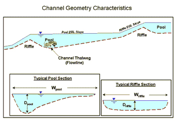
- Riffle-Pool Spacing
- Channel Width
Channel Sinuosity and Meander Belt

Sinuosity is the ratio of the length of the centerline of the channel (CL) to the length of a line defining the general trend of the valley or stream reach (VL) and describes the amount of meandering in a stream.
Sinuosity = CL / VL
Channel Planform Characteristics

Some commonly used relationships for planform in natural stable systems are as follows:
- 10 to 14W
- Riffle spacing 5 to 7W or ½
- rc 2 to 3W
In general pools are located in bends, riffles are located near crossings. It should be noted that the relations for wavelength and radius of curvature have been most often been identified in stable natural systems and should be used with discretion in the urban environment. This is because impervious watershed conditions accelerate the erosion process and can cause a shift from the natural condition. However these relationships are used as a starting point for many channel reconstruction projects. They can be used to determine whether a system is “out-of-phase” and provide design targets for stabilization projects. From historical observation and common planform relationships the Stream Restoration staff are able to ascertain the probability of bank retreat in a particular area.
Channel Geometry and Profile Channel geometry refers to the cross sectional and longitudinal parameters that affect the amount of channel conveyance and hydraulic forces on the channel boundary. Some common channel geometry parameters are:
- Channel Width
- Flow Area
- Hydraulic Radius
- Hydraulic Depth
- Depth of Flow (maximum depth)
- Width/Depth Ratio
- Bank Height
- Channel Profile
The channel geometric parameters vary throughout a stream reach depending on location these can be averaged to estimate the "reach-average" conditions for certain types of evaluation and analysis.
Relationships that relate channel geometry to hydrology are termed “regime equations” and are based on observations of a large group of streams. These relationships usually take the form of:
- W = aQb
- d = cQf
- V = kQm
- S = fQz
For width (W), depth (d), velocity (V) and slope (S)
As with planform channel geometric relations are only relevant in stable systems and should be used with discretion in the urban environment. In areas with rapid land-use change such as developing watersheds relationships such as these may be useless for design. However they may be used for comparative purposes. In older or undeveloped watersheds they may prove more functional. In general more detailed analyses are required to determine appropriate stable channel geometry in areas where watershed land use has been altered.
Drainage area is also used as a surrogate to discharge in channel geometry relationships. It has been observed that the trend is and upward shift in the relationship for channel width to drainage area as a result of urbanization.

The channel adjustment process resulting from urbanization can also be expressed with incised channel evolution model proposed by Schumm (1984).

The critical bank height at which mass failure begins is described as hc. when the bank height (h) exceeds hc (Stages II - III) geotechnical failures can be expected.
Observations in Austin indicate that the progression from Stage I to II occurs quite rapidly (10- 30 years) and the widening and restabilization process (Stage IV – V) occurs over a much longer time frame. Most of our urban streams that have been impacted are currently in stages II & III. This identification allows us to utilize other empirical and analytical methods appropriately. The channel evolution model serves to tell us:
- Where the Channel has Been
- Where the Channel is in its Evolution
- Where the Channel is Going
It is important to identify the channel stage of evolution in order to develop appropriate mitigation strategies and reduce future adverse impacts.
Bed Material Characteristics The size, shape, composition and distribution of material in the channel bed are important to the channel stability. These characteristic are used to determine the mobility of the channel bed and subsequently the erosion potential. In general larger sediment sizes (cobbles/boulders) act to stabilize the channel bed, where smaller particles (sand/silt) are more readily erodible. The distribution of particle sizes in bed material mixtures affects the ability of water to mobilize these sediments. The characteristics of the bed material are analyzed through visual observation and gradations developed from sieve analyses or pebble counts.
Bed Material Gradation Curve

A well-sorted sediment mixture consists of grains that are of uniform size and a poorly-sorted sediment contains particles of many sizes. A poorly-sorted sediment may be indicative of a high energy/flashy system. A poorly-sorted stream may also include large particles that armor the channel bed.
The shape of the bed material affects its stability. Angular particles will provide more stability than rounded particles because of the interlocking and friction characteristics.
The chemical composition of the bed material particles affect how it breaks-down, changes size and shape as the material moves downstream. Weaker materials such as shale and limestone degrade faster than quartz-based sediments.
Bank Composition The type of material and stratigraphy in a channel bank affects its erosion potential. Bank stratigraphy is identified and measured in the field. Geotechnical analyses are performed to analyze the strength characteristics of the bank materials. Many channels in Austin are comprised of composite channel banks with bedrock, clay, alluvium and soils.
Composite Channel Bank in Shoal Creek

Composite Channel Bank in Onion Creek
Riparian Vegetation Vegetation acts to provide channel stability as the root systems strengthen the bank material and resist erosive forces. Deep rooted plants and trees give internal strength to the soil mass comprising the channel bank. Shallow rotted plants such as grasses provide more erosion resistance to surficial forces from flowing water. In addition riparian vegetation is an essential component of the aquatic ecosystem.
Roots in the Channel Banks

Geotechnical analyses are used to determine existing bank stability, anticipate bank failures and to provide design parameters for embankment construction. Bank failure can occur in various modes depending on the bank soil properties and the morphology of the stream. Some bank failure modes include shallow, planar, rotational and cantilever type failures. The most common type of bank failure in our urbanized stream results from removal of soil from the channel toe (undermining) and subsequent slope failure.
Bank Failure Modes


In design of bank stabilization projects the primary components of a slope stability analysis include evaluation of:
- External Stability
- Internal Stability
- Local Stability
- Global Stability
External stability refers to the acting and resisting forces adjacent to stream that influence stability of the constructed slope. External stability analysis evaluates forces related to bearing capacity, base sliding and overturning moments.
Internal stability refers to forces within the channel bank that affect the stability of reinforcements (internal sliding, tensile overstress, and pullout).
Local stability is related to the surficial facing of a channel bank. This also relates to the connection strength between the facing and internal reinforcements in a constructed slope.
Global Stability relates to deep seated rotational failures that are generally outside the limits of a constructed slope.
Rock riprap is a layer of loose rock used to protect soil from the erosive or scouring flows of water. Rock riprap is sometimes used for bank protection or bed stabilization in stream restoration projects where other erosion control techniques are not appropriate.
In order for the rock riprap to properly function, installing rock of good quality and the proper size gradation is important. Design criteria for rock riprap are listed in the Environmental Criteria Manual (ECM) Section 1.4.6. Rock riprap materials and construction methods are described in City of Austin Standard Specification 591S.
The Watershed Protection Department recommends a field gradation test method for use during construction projects to verify that the specified rock will be installed. The gradation test method is described in the following documents, and an example analysis worksheet is provided. However, engineers may use an alternate preferred method conforming to ECM Section 1.4.6.

- Topographic and Bathymetric Survey
- Bed Material Pebble Counts and/or Sieve Analyses
- Geotechnical Borings and Soil Strength Testing \
- Historical Aerial Photography
- Historical Comparative Channel Cross Sections and Profiles
- Existing Hydraulic and Hydrology Models and Floodplain Information
- Watershed Mapping (GIS)
Family Clean Creek Camp
No, we cannot accommodate younger children.
Yes, there is a high demand to attend camp so please be committed to attending the full week.
Various sites around Austin. Refer to directions.
Flood Early Warning System
Check the ATXfloods for road closures. NOAA All Hazards Weather Radio will alert you to flood warnings and evacuations. Also, local TV and radio stations often keep you posted during flooding conditions.
Yes, it is a Class B misdemeanor in Texas to drive around a barricade at a flooded road. This is the same as a DWI. If caught, you may be arrested, have your car impounded, spend up to 180 days in jail and/or be fined up to $2000. You may also be charged for the cost of your rescue.
ENS stands for Emergency Notification System. These areas have been identified by the City as being more likely to require evacuation due to flash flooding than other areas. The areas have been pre-entered into our emergency notification system to expedite automated phone calls in the event of an evacuation.
If a road is flooded, turn around and find an alternate route. Don’t risk drowning by trying to cross it. Most flood fatalities occur in vehicles.
The 100-year storm is an event that has a 1% chance of occurring in any given year. To put that in perspective, during the span of a 30-year mortgage, there is a 26% chance that a 100-year event will occur.
The amount of rainfall necessary to produce a 100-year storm is dependent both on the duration of the storm and what area it impacts. If the rain falls over the course of 3 hours, it takes over 7 inches for it to be classified as a 100-year rainfall. But if those same 7 inches fall over the course of 3 days, it would be considered a much smaller rainfall event. The standard 100-year design storm for the City of Austin has a duration of 24-hours and produces a total rainfall of over 12 inches. To learn more about rainfall return periods in Austin, see Section 2 of the Drainage Criteria Manual.
During a large storm, it is normal for the intensity to vary widely across the city. In September 2010, Tropical Storm Hermine produced rainfall totals approaching a 100-year storm over portions of the Bull Creek watershed. The flood events on October 30, 2015, and May 26, 2016, produced rainfall greater that 13 inches in eight hours in portions of the Onion Creek and Dry Creek East watersheds. However, other areas of Austin did not experience as severe a storm in these events. Keep in mind that even if a large storm has recently occurred, there is the same percent chance of an equally large storm occurring the following year.
In the right circumstances, almost any road can flood. The ones listed below are the ones that flood most frequently:
- W. 12th St. from Lamar to Shoal Creek Blvd.
- W. 32nd St. at Hemphill Park
- E. 38 1/2 St. between Grayson and Airport Blvd.
- Adelphi Ln. between Scribe Dr. and Waters Park Rd.
- E. Alpine Rd. between Willow Springs and Warehouse Row
- Burleson Rd. between U.S. 183 and FM 973
- Carson Creek Blvd. between Cool Shadow Dr. and Warrior Ln.
- Colton-Bluff Springs Rd. by Alum Rock Dr.
- Convict Hill Rd. between Flaming Oak Place and MoPAC
- David Moore Dr. north of Sweetwater River Dr.
- Delwau Ln. at Shelton Rd.
- W. Dittmar between Loganberry and S. Congress
- Joe Tanner Ln., near Hwy. 290
- Johnny Morris Rd. between FM 969 and Loyola Ln.
- Lakewood Dr., 6700 block
- W. Monroe St. between S. First and Roma St.
- McNeil Dr. between Camino and Burnet
- Nuckols Crossing at Teri Rd.
- Parkfield Dr. from Thornridge to Mearns Meadow
- Possum Trot between Inland Place and Quarry Rd.
- Old Bee Caves Road, near Hwy. 290
- Old San Antonio Rd. between FM 1626 and IH 35
- Old Spicewood Springs Road, between Loop 360 and Spicewood Springs Rd.
- O’Neal Ln., between MoPAC service road and Waters Park Rd.
- Posten Ln., 7900 block
- River Hills Rd., off Cuernavaca
- Rogge Ln. between Ridgemont and Delwood Dr.
- Rutland from Mearns Meadow to N. Lamar
- Spicewood Springs Road, between Loop 360 and Old Lampasas Trl.
- Springdale Rd. from Ferguson to Breeds Hill Dr.
- Wasson Rd. near S. Congress Ave.
- Waters Park Rd. between 183 and MoPAC
To find out if a road is flooded, check www.ATXfloods.com.
Floodplain Management
It’s a good idea to determine the risk your property has of flooding. Is your house next to a creek or storm drain channel? Is it located at the low-point of a roadway or at the bottom of a hill? These are indications that flood insurance may be a good idea.
Mortgage companies usually require flood insurance for homes and businesses in the floodplain. Homeowners insurance policies do not cover flooding caused by stormwater.
Keep in mind that people outside of floodplain areas file more than 20% of flood insurance claims and receive about one-third of disaster assistance, when it is available.
For more information about who must purchase flood insurance, download FEMA’s Mandatory Purchase of Flood Insurance Guidelines booklet.
In regard to lowering your premium, you may already be getting a 20% discount because of the steps Austin takes to guard against flooding. In addition, there may be some improvements that you can make to protect your house or business from flooding. For more information, call our hotline at 512-974-2843 or send an email.
An elevation certificate may also be helpful. Prepared by a surveyor or engineer, elevation certificates show the elevation of your home in comparison with the expected elevation of floodwaters. If the certificate shows that the lowest floor elevation in your house is above the expected inundation levels, it should lower your insurance premium. The City may already have one on file for your house or business, but we cannot guarantee the accuracy. Please use FloodPro to look up whether we have a certificate on file or you may contact us by phone or email.
Download these FEMA publications to find out more about protecting your property:
- Protecting Manufactured Homes from Floods and Other Hazards
- Homeowner’s Guide to Retrofitting: Six Ways to Protect Your Home from Flooding
- Engineering Principles and Practices for Retrofitting Flood-Prone Residential Structures
- Above the Flood: Elevating your Floodprone House
- Protecting Building Utilities from Flood Damage
A drainage easement is a part of your property where the City has limited rights of access and/or use. Generally, you cannot make any improvements in a drainage easement. That means no fences, sheds, walls, trails or buildings. You should avoid planting trees or much landscaping as well.
A drainage easement has two possible purposes. It may be needed for the flow of storm water. For example, drainage ditches and creeks are typically within a drainage easement. In this case, anything that prevents the flow of water; that might catch debris; that might be washed away; or that might cause a dam-like effect is problematic.
Alternatively, the easement may be needed to access drainage infrastructure. In this case, anything that might make it difficult to drive a truck through or dig up an underground pipe is problematic.
• Risk of Property Damage: If your home is in the 100-year floodplain, it has a 26% chance of being flooded over the course of a 30-year mortgage. There are steps you can take to reduce property damage. For more information, visit www.floodsmart.gov, explore our FAQs or call our hotline at 512-974-2843.
• Safety: Flooding can be deadly. Monitor the weather, consider purchasing a NOAA Weather Radio and prepare a family disaster plan. Learn more about where the floodplain is located on our interactive floodplain map. For more information about flood safety, visit our Flood Safety and Preparedness page.
• Restrictions: Stricter permit regulations apply for any building, remodeling, construction or other development on properties in the floodplain. In some cases, it may be impossible to get a permit. For more information on restrictions, go to Floodplain Development Information.
Depending on how much rain there’s been, Austin’s creeks may be bone dry, gently flowing with water or a raging torrent. The floodplain is the area of land that is likely to be under water when the creek rushes over its banks. In a sense, the floodplain is the full extension of the creek.
The 100-year floodplain is the land that is predicted to flood during a 100-year storm, which has a 1% chance of occurring in any given year. You may also hear the 100-year floodplain called the 1% annual chance floodplain or base flood. Areas within the 100-year floodplain may flood in much smaller storms as well. The 100-year floodplain is used by FEMA to administer the federal flood insurance program and the City of Austin to regulate development.
The restrictions protect lives and properties. They ensure that development doesn’t cause additional flooding on other properties. In addition, they ensure that the development itself minimizes the risks of flooding. Many of the development restrictions are federal requirements in order for Austin citizens to be able to purchase federally-backed flood insurance from FEMA.
Groundwater
Barton Springs has been called "the soul of Austin" with a history of human activity that dates back at least 10,000 years. It is the main discharge point for water that enters the Barton Spring segment of the Edwards Aquifer.

Monitoring water quality at Barton Springs is essential for assessing the cumulative impact of development on the entire Barton Springs Edwards Aquifer as well as for endangered species protection and preservation of the unique swimming site. An automatic sampler is stationed at Barton Springs to collect data on pH, temperature, turbidity, specific conductivity, dissolved oxygen, and depth. Watershed Protection groundwater monitoring staff test for suspended solids and nutrients every two weeks. Additionally, twice weekly, and following rainfall over one inch, the Parks and Recreation and/or County Health Departments test for bacteria levels.
Barton Springs is actually comprised of four separate but related spring outlets.
- Main Barton Springs, also known as Parthenia, discharges from the aquifer directly into the pool from numerous fractures and openings upstream of the diving board area. This is also where the endangered Barton Springs Salamander is primarily found.
- Eliza Spring discharges into a concrete amphitheater on the north side of the pool near the concession stand. Water is visible welling up from holes drilled into the artificial concrete floor.
- Old Mill Spring (Sunken Garden), also known as Zenobia Spring, discharges into a stone-walled pool on the south side of the creek downstream of Barton Springs pool and flows through a short tributary to Barton Creek.
- Upper Barton Springs is located upstream of Barton Springs Pool.
Groundwater tracing is a commonly used technique to understand water movement through karst aquifers like the Edwards. The dissolution of limestone occurs slowly over a long period of time and these opening are pathways or conduits for water to enter the aquifer and for groundwater to move through the aquifer. Tracing can use naturally occurring chemical in the water, introduced chemicals or dyes to track water movement. A tracer is typically introduced into the aquifer through a naturally occurring recharge feature and wells, springs and other water ways are monitored to detect the tracer.
A coordinated tracing program began in the Barton Springs Edwards Aquifer in 1996. Since that time, over 30 traces have been conducted. A special project began in 1996 in conjunction with the Barton Springs/Edwards Aquifer Conservation District (BS/EACD) called the Barton Springs Zone Dye Trace Study. Dye was injected into caves and sinkholes to map water movement in this segment. The goals were to trace the water going into the aquifer at various points in the recharge zone, measure flow rates, and determine which wells and springs the water would emerge from. Travel rates from recharge points to springs varied from 4 miles/day to 0.25 miles/day. Onion Creek is the largest contributor of the watersheds to Barton Springs under normal conditions, but a 2017 study shows that the Blanco River can be a significant source of recharge during drought conditions.

Grow Green
Click here to subscribe online to be notified by mail about gardening classes or call 512-974-2550 and ask to be put on the emailing list for gardening classes. You will receive notification when a gardening class is scheduled. We usually offer classes a couple of times a year. Please also check the Grow Green home page occasionally. We post classes from multiple City departments and the Travis County Master Gardeners - but will not be sending out announcements for those classes individually.
- City of Austin’s Invasive Plant Webpage
- Invasives Plant Database - To find out if a plant in your area is an aggressive non-native that competes with native plants for resources.
- Austin Resource Recovery
- Austin Energy: Green Building
- Austin Water Utility: Water Conservation and Wildlands
- Parks and Recreation Department: Urban Forestry, Wildlife Austin, Zilker Botanical Garden
- Development Services Department
- Watershed Protection Department: Grow Green
Grow Green and xeriscaping have very similar principles. Xeriscaping is landscaping whose main goal is to conserve water (Water Wise Austin). The seven principles of Xeriscape include: Planning and Design, Soil Analysis, Plant Selection, Practical Turf Areas, Efficient Irrigation, Use of Mulches, and Maintenance. Grow Green goes beyond Xeriscaping in emphasizing the use of least toxic products in the landscape. Minimizing chemical input in the landscape protects our living areas and our water ways.
Hydrilla
- To minimize fragmentation and spreading of plants, avoid boating through dense hydrilla mats.
- Remove hydrilla from your boat's propeller and trailer before and after boating.
- Dispose of all plant fragments on shore: Because new plants can sprout from fragments, all plant material cut or collected MUST be removed from the lake. Throwing hydrilla back in the lake can result in a maximum fine of $2000 per plant.
- Follow City of Austin hydrilla disposal guidelines:
- Plants should be placed as far up on the shore as possible.
- Plant material stockpiled within 75' of the water's edge should be surrounded on the downslope side by silt fencing.
- Plant material pulled from the lake will contain small fish and other organisms, and will have an odor associated with it. The plants are mostly water, and piles will lose 90% of their bulk within 2-4 weeks. This material can be used to mulch flowerbeds or gardens.
- Learn more about Friends of Lake Austin (FOLA) - a citizen group dedicated to preserving and enhancing Lake Austin for those who live, work and play on the lake. They have been working to help fight the hydrilla infestation on Lake Austin and are taking an active role in the approved management plan
Hydrofiles
Contact Sara Heilman email or phone 512-974-3540. Our training kit contains 6 sets of the following kits: Dissolved oxygen, pH, TDS, nitrate, and E. coli. The kit may be checked out and we provide training for your students if required. You may also request one free complete test kit.
Water test kits are available for teachers and classes for educational use. General use kits may be requested through Keep Austin Beautiful
Integrated Pest Management, Integrated Pest Management
GROW GREEN FACT SHEETS are available to download or you can also pick hard copies from many sites around Austin that distribute Grow Green materials.
Other Common Pests and Grow Green Recommendations
The landscape problems listed below occur in Austin but we do not have the same demand for information about them as the pests that have GROW GREEN FACT SHEETS.
Bacterial Leaf Spot
Problem
Leaves yellow and may drop. Plants lose vigor and produce less chlorophyll. Bacterial Leaf Spot is caused by wet plant foliage and injury. This is commonly seen on:
Greens
Turnips
Cauliflower
Cabbage
English Ivy
Tomatoes
Fruit trees
Several ornamental shrubs and trees
Least Toxic Solutions
- Avoid wetting foliage when watering.
- Space plants to allow adequate air flow.
- Do not injure foliage. Bacteria enter plants through wounds or natural openings.
- Remove infected plant sections.
- Carefully consider use of chemical controls— they are often only marginally effective.
- If you must use a chemical control, apply a copper hydroxide product such as Kocide®.
Cotton Rot/Root Rot
Description: Fungal plant disease that attacks the roots of plants, turning them brown rather than a healthy white. Cotton root rot is common in soils with a pH over 7.2 and in areas with high summer temperatures. Problem: Plants wilt, dieback and lose vigor. Control is difficult because symptoms normally appear after damage to the stem or root is severe. Cotton Root Rot moves through the soil from plant to plant, with symptoms usually occurring in July and August.
Attacks: More than 2,000 species of plants including:
Cotton
Ornamentals
Fruit trees
Nut trees
Shade trees
Most landscape plants
Least Toxic Solutions
Cotton Root Rot
No treatment available once plant is infected. Mulch plants to keep soil cool. Add organic material to clay soils. Use resistant plants, natives and grasses. When practical, acidify soil in the root zone of the plant.
Root Rot
Ensure proper drainage and allow excessively wet soils to dry. Plant in raised beds if drainage is marginal. Avoid crowding plants in beds. Place plants at the same soil depth as they were in the container you purchased them in. Because there are several different fungi that cause root rots, have the disease diagnosed at the Texas A & M Plant Disease Lab or by Extension personnel before applying fungicide.
Fire Blight
Description: Bacterial disease that causes rapid blackening and desiccation of blooms and foliage. Affected shoots bend at the tip in a "shepherd's hook". Black, sunken twig and branch cankers develop later. Problem: Fire Blight causes twig dieback and blossom blight in up to 2-24 inches of twig length. The bacterium stays in the cankers over winter and in the spring, oozes from the cankers and is carried by wind, rain and insects to healthy foliage.
Attacks:
Pears
Apples
Pyracantha
Quince
Loquat
Indian Hawthorne
Photinia
Least Toxic Solutions
Avoid high nitrogen levels and excessive pruning. Vigorous growth is much more susceptible to fire blight. Prune four inches below visible cankers. pruning equipment between cuts with one part household bleach to nine parts of water. Clean and oil equipment after pruning. Select fire blight resistant varieties and species. Contact the Extension office at 854-9600 for a list. With the exception of Kocide® and streptomycin sulfate, chemical controls are usually ineffective.
Oak Wilt
Description
Fungus that plug water-conducting vessels, reducing flow of water up the stem of the tree. Often causes leaves to wilt and fall prematurely. Live Oaks: Tree appears weakened. One area of the tree dies at a time. Areas around leaf veins are often brightly colored.
Red Oaks: Die in a flash of fall color in early summer.
Problem
Disease spread by beetles feeding on tree wounds. Also can travel from tree to tree through interconnected roots. Oak Wilt travels 75 feet per year in all directions. Live Oaks die quickly one tree at a time.
Attacks
- Blackjack Oak
- Live Oaks
- Schumard Oak
- Spanish Oak/Texas Red Oak
Least Toxic Solutions:
- Prune oak trees only in the coldest part of winter and hottest part of summer.
- Use a pruning paint to protect cut or wounded areas immediately after pruning or wounds are discovered. Sterilize tools after pruning.
- Contact Chris Dolan, City of Austin Oak Wilt Suppression Program at 512-974-1881 for information.
- Trench 4' deep and at least 100 feet from infected and susceptible trees to sever root connections.
- Only use old, dry wood if you use oak firewood.
- Certified applicators can inject ALAMO® into tree roots. This method is best used as a preventative.
Thrips
Description
Description To the naked eye, they look like tiny threads; with a hand lens, their narrow, fringed wings are visible. When holding an infested rose bloom you can see that they are very active. They may even bite!
Infestation
Tattered flowers, deformed flowers, silvery spots or streaks on leaves - by the time damage is visible the infestation is already severe.
Attacks:
- Roses
- Daylilies
- Iris
- other flowers
Lifecycle
Adults lay hundreds of eggs in plant tissue. In Roses, the eggs hatch inside the flower bud. The resulting nymphs scrap plant tissue, then, suck the sap, damaging the flower before it opens. There are many generations per year.
Least Toxic Solutions: Thrips are notoriously very difficult to control, so early detection is important when trying to keep the populations in check.
Aim for control rather than eradication. The only way to completely get rid of thrips is to destroy the infested plants - not an option most want to consider
- Remove and dispose of infested blooms
- Clean up leaf litter
- Always read and follow pesticide labels
-
Alternate the following treatments:
- Spray with Neem oil. For best results the spray needs to come in contact with the insect, but Neem oil is also slightly systemic; meaning some of it will absorb into the plant tissue and help weaken the insect after it feeds on the plant
- Dust plants and immediate area with diatomaceous earth Use a light weight horticultural oil
Viruses
Description
Sub-microscopic infectious particles that multiply only inside living cells. Viruses enter plants through wounds and by insects that feed on plants. Symptoms vary but include abnormal color, vein patterns, shape, mottling, ring spots and mosaic patterns in leaves; Can include abnormal flower color and fruit size, shape and color.
Problem
Seldom lethal to plants, but severely affect the quantity, quality and longevity of the host plant.
Attacks
Many types of plants.
Least Toxic Solutions:
- Chemicals do not effectively control virus diseases.
- Select plant stock that is free of viruses.
- Cover susceptible annual garden plants with a row cover fabric to keep sucking insects away from healthy plants.
- Diseased plants should be removed and destroyed to prevent infection of other plants by sucking insects that move from plant to plant.
Additional Links
Integrated Pest Management
The Save Our Springs Ordinance (SOS) was adopted in 1992 and differed from its predecessors because it became law by citizen initiative. Two ordinances worth noting preceded the SOS Ordinance: the Interim and Composite Ordinances. These ordinances addressed development in the Barton Springs Zone, which includes Barton Creek and the other creeks draining to, or crossing, the Edwards Aquifer recharge zone. Highlights of these ordinances included: the first requirements for non-degradation (based on stormwater discharge concentrations) and provisions that excluded variances unless a demonstrable improvement in water quality was shown. Variances, which made departures from an ordinance permissible, were a general feature of watershed ordinances up until this time.
The SOS Ordinance, applied throughout the Barton Springs Zone, required: non- degradation (based on total average annual loading), and lowered impervious cover to 15 percent NSA for all development in the recharge zone, 20 percent NSA for development in the Barton Creek portion of the contributing zone and 25 percent NSA for development in the remaining portions of the contributing zone in Williamson, Slaughter, Bear, Little Bear and Onion Creeks.
Landscape Professional Training
August 25, 2015
Know Your Role - Know Your Role
Will Boettner, Texas A&M Forest Service
Virtual Assessments
Virtual Assessment 1
Virtual Assessment 2
Virtual Assessment 3
Virtual Assessment 4
Environmentally-Minded Mitigation - Environmental BMPS for Firewise Landscaping
Ryan Hebrink, Watershed Protection
Mitigating to Preserve High-Value Trees - Mitigating to Preserve High-Value Trees
Michael Embesi, City of Austin Arborist
Wildland Fire: The Good, The Bad, and the Ugly - Wildland Fire: The Good, The Bad, and the Ugly
Lucien Ball, Austin Water Utility
Fire Effects on Native Landscaping - Fire Effects on Native Landscaping
Michelle Bertelsen, Lady Bird Johnson Wildflower Center
Landscaping for Wildlife in the Wildland Urban Interface - Landscaping for Wildlife in the Wildland Urban Interface
Meredith Gray, Parks and Recreation
July 21, 2015
Water Conservation: Drought Update
Drema Gross - Water Conservation Division Manager, Austin Water
Gray Water: Navigating Through City Code
Robert Stefani - Conservation Program Specialist, Austin Water
Gray Water: Projects and Irrigation Connections
Chris Maxwell-Gaines, P.E. - Innovative Water Solutions, LLC
Reclaimed water: Using Bulk Fill Stations
Bill Kemp - Caracara Farm
Design: Earthworks and Landscape Design for Water Conservation
Betty Lambright - As Right As Rain
Soil: Contractor Use of Soils
Jared Pyka - ValleyCrest
Water Conservation: Water Conservation Landscape Programs
Chris Charles - Water Conservation Associate Austin Water
June 23, 2015
Creekside Landscaping - Riparian Restoration
Ana Gonzalez, Watershed Protection Department
Green Infrastructure Working Group - Integrate Nature Into the City
Erin Wood - Watershed Protection Department
So You want to Build A Rain Garden - So You Want to Build a Rain Garden
Tom Franke, EIT & Michelle Adlong, Watershed Protection Department
Turf Problems and IPM - Lawn Problems an integrated pest management approach
Daphne Richards, County Extension Agent—Horticulture Texas A&M AgriLife Extension Service
Ants: Identification, Biology and Management - Ants: Identification & Management
Wizzie Brown - Texas A&M AgriLife Extension Service
Mosquitos - Integrated Mosquito Management (IMM)
Sabrina V idaurri, MS, RS, City of Austin/Travis County Health Department
March 24, 2015
Plants Running Hot & Cold - Plants Running Cold, Hot & Dry
Denise Delaney, City of Austin Watershed Protection
Austin’s Tree Regulations - Austin's Tree Regulations
Michael Embesi, PDRD Tree Program
Landscaping with Trees for Water Conservation - Designing for Trees for Drought
Vincent Debrock
Native Plant Combos - Native Plants for Texas Landscapes
Andrea DeLong-Amaya, Lady Bird Johnson Wildflower Center
Professional Pruning - Professional Prunning
Laura Schuman, Parks & Recreation Department
Plants for Rain Gardens & Bioswales - Plants for Biofiltration Systems
Elizabeth McGreevy, Roc + Solid Land Design
Feb 24, 2015
Big Picture Local Food System - Austin's Sustainable Food System is a Local One
Edwin Marty
Alternative Ways to Water - Alternative Gardening and Watering Methods
Meredith Gray, City of Austin Parks and Recreation Department
Chris Sanchez, City of Austin Parks and Recreation Department
Rainwater Harvesting - Rainwater Harvesting for Grow Green Professionals
Dick Peterson
Sustainable Landscaping with Tough Herbs - Sustainable Landscaping with Tough Herbs Colleen
Dieter, Red Wheelbarrow
Landscaping for Wildlife - Landscaping for Wildlife
LaJuan D. Tucker, City of Austin Parks and Recreation Department
Sustainability
"Many of the conservation techniques/practices will be applicable"
"Knowledge of the presenters, and enough time available for in-depth treatment of topics."
"Diverse speakers, great information, great atmosphere and attitudes"
Plants
"The best thing about today’s training was the variety of speakers and material presented was very practical…can implement in the field immediately".
"The tree pruning information was highly informational"
Water Quality and Integrated Pest Management
"I love rain gardens! I learned a lot of new information on different designs, testing soil, infiltration and filtration"
"Plan to apply ant identification, rain gardens, bio media information and encouraging creekside wilding"
Water Conservation
"I love how you start with information on drought updates and city codes then beef up (or tofu) the subject!"
"I always learn a lot from these trainings. I liked that most everything flows well and is on time."
Firewise
"My organization is concerned with risk. This is a risk we don’t yet manage. This is a good way to start".
"I appreciate the level of expertise that you provided for the training sessions."
January 15th, 2016
Bob Rose, LCRA Chief Meteorologist
Spring and Summer Weather Outlook
Lauren Stanley, Stanley Studios Architecture + Metalwork
Urban Nature: Propagating Green Roofs
Jonathan Garner, Lady Bird Johnson Wildflower Center the University of Texas at Austin
Introduction to the Sustainable Sites Initiative
Heather Venhaus, Regenerative Environmental Design, LLC
High Performance Urban Ecosystems
Staryn Wagner, Watershed Protection Department
Leaky Cisterns: Better Than Good, They're Great!
Katie Coyne, Asakura Robinson Company
Connecting Systems and People Using Urban Ecological Planning and Design
Kirby Fry, Southern Culture
Sustainable Design & Urban Permaculture
January, 29th, 2016
Hank Smith, Home Builders Association of Greater Austin
Sensible Landscaping for Central Texas
Brett Briant, Lower Colorado River Authority
Water Conservation Rebates and Programs
Amy Uyen Truong, Texas A&M Institute of Natural Resources
Forrest Cobb, Texas A&M Institute of Natural Resources
The Drought Survivability Study
Matthew Stamm, Cougar Irrigation
Efficient Irrigation Techniques
Susan Kenzle, RLA, LI, ISA
Darcy Nuffer, RLA, LI, LEED AP - City of Austin, Watershed Protection Department
Rain Gardens: Plant selection
Tom Franke - City of Austin, Watershed Protection Department
Michelle Adlong - City of Austin, Watershed Protection Department
So You Want to Build a Rain Garden… What have we learned so far?
February 12, 2016
Andrea DeLong-Amaya, Lady Bird Johnson Wildflower Center
Plant Selection for the Family Garden at the Lady Bird Johnson Wildflower Center
James Plyer, Native Texas Nursery
Trowel and Error: Overcoming the Challenges of Providing Native Plants (and sometimes not)
John Clement, Watershed Protection Department
Dealing With Invasive Plants in Residential and Commercial Landscapes
Liz McVeety, Parks & Recreation Department
Perils and Pleasures of Pruning
Keith Brown, Austin Tree Experts
Myths and Fact About Trees
Vincent DeBrock, Heritage Tree LLC
Trees and Soil: Why Landscapers are Key for the Urban Forest
February 26, 2016
Mitchell Wright ASLA, AICP, LEED AP, Vista Planning and Design
Festival Beach Food Forest Case Study
Meredith O'Reilly, 4-H CAPITAL Project/Texas A&M AgriLife Extension Service
Supporting Wildlife with Habitats and Integrated Pest Mana
Robinson Sudan, New Leaf and Pollinator Partnership
Role of Pollinators/IPM
Christopher Sanchez, City of Ausitn Parks and Recreation Department
Straw Bale Planting Demonstration
Cathy Downs, Hill Country Master Naturalist, Bring Back the Monarchs to Texas Program
Milkweeds and Monarchs Made
March 11, 2016
Justice Jones , Austin Fire Department
Firewise Design Considerations
Sarah Dooling, University of Texas at Austin School of Architecture
A Future Vision of Design Practice in the Context of Uncertainty, Rapid Change and Inequities
"Speakers seem very knowledgeable on their topics. Minimal repetition but building on each other well."
"Directed to us, the professionals. Up-to-date information; very insightful."
"Learned a lot of new tree care methods."
"Reminded me our natives are as beautiful as any landscape plants promoted by books for other parts of the US."
"Have really enjoyed just learning about people in the industry (speakers). Has expanded my scope and resource base."
"Really enjoyed the hands-on sessions."
Sustainability - January 15, 2016
Spring and Summer Weather Outlook
Urban Nature: Propagating Green Roofs
Introduction to the Sustainable Sites Initiative
High Performance Urban Ecosystems
Leaky Cisterns; Better Than Good, They're Great!
Connecting Systems and People Using Urban Ecological Planning and Design
"Lots of good information from people who have actually put procedures into practice & could report factual results."
"The sessions get better every year! Thanks!"
"Presenters were all excellent! Dynamic, inspiring, professional, knowledgeable!"
"Subject matter was something I can apply myself."
"I understand rain gardens so much better now and will be able to help others design & implement them."
"The networking opportunities were really good!"
"The speakers were all very interactive & engaging – enjoyed the fluidity of the topics too!"
"I liked all of the hands-on segments."
"I learned a lot of good tree care tips"
"So excited to up my compost game! Definitely going to refresh the landscaping crew on tree planting!"
"The info SITES information was definitely helpful to keep in mind for future projects!!"
"I plan to take fire safety into consideration much more than I did before!"
"The technology in the landscape presentation gave lots of good information on new options for landscape industry applications."
"I plan to try to push more innovative uses for alternative water sources."
January 23, 2019 – Rainscapes and Cisterns
Introduction to Green Stormwater Infrastructure
Paige Oliverio, Urban Patchwork
Rain Gardens - Design & Installation
Tom Franke, Watershed Protection
Rain Gardens - Plants & Maintenance
Susan Kenzle & Darcy Nuffer, Watershed Protection
Rainwater Harvesting
Billy Kniffen, Texas A&M AgriLife Extension Service (retired)
Passive Cistern Design handout
Staryn Wagner, Watershed Protection
High Efficiency Irrigation and Holistic Water Management
Brenton Donnell, Innovative Irrigation Technologies
Drainage Utility Fee & Discount Program
Kellsey Schilly, Watershed Protection
February 7, 2019 – Sustainability
Planning for the Future: Sustainable Landscaping
Denise Delaney, Watershed Protection Department
Using Reclaimed Wood for Outdoor Projects
Andrew Danziger, Hatch Workshop and Harvest Lumber Co.
Growing for the Future: The Luci and Ian Family Garden
Andrea DeLong-Amaya, Lady Bird Johnson Wildflower Center
Handout
Designing with the Sustainable Sites® Initiative in Mind
Kimberly Gilbertson, MLA, Public Works
Green Roofs
John Hart Asher, Lady Bird Johnson Wildflower Center
February 21, 2019 - Trees, Edible Plants & Attracting Wildlife
Benefits of Nature
Dr. Cindy Klemmer, Parks & Recreation Department
How Trees Grow
Paul Johnson, Texas A&M Forest Service
Tree Regulations & Critical Root Zone
Cinthia Pedraza, Development Services Department
Attracting Wildlife
Kelly Simon, Texas Parks & Wildlife
Fruit Tree Pruning
Greg Mast, Central Texas Food Bank
March 7, 2019 - Fire & Water
Gray Water
Robert Stefani, Austin Water
Irrigation Technology
Johnny Anderson, Rachio
Reducing Wildfire Risk in Landscapes: Tools & Resources
Mark Baker & Mark Stinson, Austin Fire Department, Wildfire Division
"I am just happy that everyone else is finally catching up to the importance of rainwater harvesting."
"The speakers were all exceptional! I learned so much!! I'm looking forward to the other three training sessions. If they are half as good as this one was, I will be very pleased."
"Thank you for all of your efforts in organizing the speakers, wonderful lineup this year. Kudos!!"
"Came away feeling very inspired to work harder to keep water on the site, and to recommend others do the same."
"Thank you for bringing experts from different areas"
"Thanks for another fascinating and educational day!"
November 17, 2020
Videos
Description -
Design – Lessons Learned, Helen Ivor-Smith, Environmental Survey Consulting
Permeable Paver Installation & Maintenance, David Hasness, Keystone Hardscapes
Tree Care & Diagnosis, Daniel Priest, Development Services Department
Description -
Principles of Landscape Design, Merredith Jiles, Parks& Recreation Department
Presentations
Design – Lessons Learned, Helen Ivor-Smith, Environmental Survey Consulting
Permeable Paver Installation & Maintenance, David Hasness, Keystone Hardscapes
Tree Care and Diagnosis, Daniel Priest, Development Services Department
8 Principles of Landscape Design, Merrideth Jiles, City of Austin Parks & Recreation Department
November 18, 2020
Video
Description -
Planting Demonstration, TaraRose Macuch, Wild Heart Dirt
Designer’s Toolbox, Merrideth Jiles, City of Austin Parks & Recreation Department
Austin Water Rebates, Chris Charles, Austin Water
Presentations
Plant Selection Tips, Crystal Murray, Far South Grower’s
Designer’s Toolbox, Merrideth Jiles, City of Austin Parks & Recreation Department
Austin Water Rebates, Chris Charles, Austin Water
People who have never taken the training will get priority. If you have attended the series in the past and wish to take the entire series again please select that option on the registration form. On the registration deadline, Watershed Protection Department staff will review registration forms and if additional spaces are available they will be filled in the order registration forms were received.
You will be notified if registration for the full series is not available and given the option to register for individual classes instead.
Landscape contractors and developers, and property managers based in Austin; as well as City of Austin employees involved with landscape design, installation or management responsibilities are eligible to take the Grow Green Landscape Professional Training series.
To determine if a business is Austin-based we ask if you have a physical Austin address or have the majority of your customers in Austin when you complete the registration form.
Yes.
The City’s Green Garden program has been merged with the City’s Grow Green program to avoid confusion due to similar names and to reach more people with a consolidated website.
This series is now called Grow Green Landscape Professionals Training. The program continues to offer the same high-level of training and professionals who complete the training series will be recognized on the webpage for one year. After completing the entire series, professionals must attend one Grow Green training day per year to maintain their presence on the webpage.
Why has the word certification been taken out of the name?
After evaluating the program, it was determined the classes do not justify the term “Certified.” The City’s Grow Green program does not have the authority to provide landscaping certifications. All of the benefits will remain the same – only the name has changed.
Participants will continue to receive educational classes on a variety of timely topics, recognition on the Grow Green webpage, CEUs, and the right to link to the Grow Green webpage from their businesses websites.
Let's Can It
- Causes pollution (from the breakdown of plastic, cigarette butts, batteries, motor oil, paint, and other toxic trash)
- Decreases oxygen levels as it decays in the creek
- Destroys aquatic habitat Harms animals living in water
- Decreases property values
- Attracts other types of crime
- Makes the City look ugly
- Cost taxpayers money to clean up
Wind and rainwater wash pollutants downhill to the lowest point in the area - the creek or the lake. Trash is the largest and most visible pollutant in urban creeks.
Plants
Salamanders
The Austin Blind Salamander is known only from Barton Springs. Unlike the Barton Springs Salamander, Austin Blind Salamanders are not typically seen near the surface. Austin Blind Salamanders occupy the habitat below the surface of the springs, where their unique adaptations likely give them a selective advantage in a world of total darkness and limited food. They have been found in all four of the springs collectively known as Barton Springs: Parthenia in Barton Springs Pool, Old Mill (Sunken Garden), Eliza and Upper Barton. Unfortunately, because their habitat is not readily accessible by humans, and they are only occasionally observed in the springs, very little is known about the natural history of this species.

Old Mill Spring (Sunken Garden) in Zilker Park is the site where the Austin Blind Salamander (Eurycea waterlooensis) was first collected.
Interestingly, another large spring in Texas is also home to a pair of salamander species: San Marcos Springs in San Marcos (Hays Co.) has surface-dwelling San Marcos Salamanders (Eurycea nana) as well as the subterranean Texas Blind Salamanders (Eurycea rathbuni).
All three Eurycea salamanders that inhabit Austin springs are members of the family Plethodontidae, which is the largest family of salamanders. They are within the sub-family Spelerpinae, which includes four genera: Eurycea, Gyrinophilus, Pseudotriton, and Stereochilus. A total of thirteen species are now described from this group of (mostly) perennibranchiate salamanders that inhabit central Texas.
Very little was known about any of Austin’s endemic brook salamanders prior to the 1990s, even though they consisted of three very different species. Prior to discovery and formal description of each species, the majority of brook salamanders (genus Eurycea) found in spring-fed surface streams throughout the Edwards Plateau of central Texas (including the Jollyville Plateau) were considered Eurycea neotenes, the Texas Salamander. In the mid-1990’s, biologists undertook studies to understand the ecology (the relationships between the salamander and its environment) and evolutionary history (e.g., the genetic relationships between the salamander and other species) of this group of salamanders. Through those studies, biologists discovered that the Texas Salamander was, in fact, comprised of several genetically distinct species. The true range of the Texas Salamander is actually restricted to the springs and caves of Bexar, Comal, and Kendall Counties. Two of the newly discovered species were Austin’s own E. tonkawae, the Jollyville Plateau Salamander2, and E. sosorum, the Barton Springs Salamander1.
The primary reason so many different species across a relatively broad geographic range were considered conspecific (the same species) is that all of the Edwards Plateau species are very similar in appearance. Before the invention of methods to examine DNA and protein molecules, differences in physical appearance, or “morphology,” were the basis for distinguishing one species from another. At that time there was no evidence to classify the Edwards brook salamanders as separate species. Once scientists learned how to test molecules and use the results to identify and group species based on their genetic relationships (the science of molecular systematics), the unique genetic characteristics of each species of salamander became apparent, and each could be classified.
Of course there were some exceptions to this prior “lumping” of different species under one name. Most notably are the subterranean species, Austin Blind Salamander, Blanco Blind Salamander, and the Texas Blind Salamander, who exhibit very obvious and extreme differences in the morphology of their bodies and heads. For one, they are “blind,” or to be more specific, they lack an image forming eye. They also tend to have larger, shovel-shaped heads. These features are believed to confer an advantage for living in complete darkness, although scientists still debate the origin of troglomorphic characters as “regressive evolution” or resulting from natural selection. Before the discovery of the Austin Blind Salamander in Barton Springs, the members of this group were considered to be in a different genus altogether (Typhlomolge) because of their extreme morphology. But once again the molecular data2,3 allowed biologists to learn that these species are genetically similar enough to the other Edwards Plateau species to be included in the genus Eurycea.

A cladogram showing the evolutionary relationships of the central Texas Eurycea salamanders. Species that occur in Austin are highlighted in grey. Branch lengths do not reflect genetic distance or substitution rate. Note that none of the species in Austin are each other’s closest relatives; thus illustrating the complex and interesting evolutionary history of this group. From Chippindale et al. 2000 and Hillis et al. 2001.

Range map of all the central Texas Eurycea salamanders.
Most of what we know about the life history of Austin Eurycea is based on observations made of the salamanders while in captivity. While many of these observations are of the Barton Springs Salamander, some characteristics (such as courtship) are thought to be common to the whole group. Courtship behavior involves a series of steps called a “tail-straddling walk,” which is characteristic of the family (Plethodontidae) of salamanders to which central Texas Eurycea belong. In the “walk,” the female straddles the male’s tail and rubs her chin on the base of his tail as he walks slowly forward; he stops at times and undulates his tail, possibly dispersing pheromones or showing her the location of his spermatophore. He eventually deposits a spermatophore that she will pick up in her cloaca. The eggs will be fertilized as they pass through the oviduct as they are being laid. After courtship, the female may wait months or a year or more before she lays her eggs. It is not known whether multiple males sire a single clutch of eggs.
The female (white eggs are noticeable in her abdomen) follows the male, he undulates his tail, possibly showing her where he has deposited his spermatophore.
All three species are thought to lay their eggs in the aquifer below the surface (especially so for the Austin Blind, who rarely visits the surface). This is because only a few eggs have ever been found in the wild; those eggs were thought to have accidentally washed up on the surface of the spring. Egg-laying events have only been observed in captivity.
On average, a female lays 15 eggs in a clutch. The eggs are laid singly and this process can take 12 hours or more. The ova are white and are surrounded by several layers of a clear capsule that is permeable for gas exchange. The capsule protects the embryo and is sticky, which presumably allows the female to lay the eggs on rocks in flow.
This is a time lapse video of embryo development for the Barton Spring Salamander. Notice the development of the eyes, gills, front limbs, and the heart beating in the throat area. This individual developed the back limbs after hatching.
The eggs hatch in 3-4 weeks. Hatchlings are ~½” total length (snout to tip of tail), often without fully formed limbs. Juvenile salamanders become sexually mature at about 11 months (50mm total length) and grow to about 3 inches as adults. Salamanders can continue to reproduce to an age of at least eight years.
The salamanders are one-half inch in length when they hatch and grow to about 3 inches in total length as adults. They have a muscular tail used for swimming. They do not spend much time swimming in the water column, however, and instead walk along the substrate*. They have 4 toes on their front feet and 5 toes on their back feet. The color variation for the Barton Springs Salamander includes shades of pink, purple, brown, orange, red as well as white spots called iridophores. The Austin Blind Salamander is generally lavender or purple with white iridophores.
![]()
This is a cleared and stained specimen of E. sosorum. The “clearing” process makes proteins transparent while the “staining” stains all cartilage blue and bone red. This is a very useful technique to allow researchers to study the bone structure of an amphibian without destroying the connective tissue.
The Barton Springs and Jollyville Plateau salamanders have eyes with image-forming lenses to help them see predators and prey. In contrast, the Austin blind salamander only has eyespots that may help it detect light. It cannot see and does not need eyes in the darkness of the aquifer.
Notice the color variation between the individual Barton Springs Salamanders shown in the video of the animals in the wild (see section on Austin Blind).
Central Texas Eurycea are aquatic their entire lives. This video shows how aquatic salamanders respire. This close-up of an Austin Blind Salamander shows red blood cells rapidly moving through capillaries in the salamander’s external gills. In this process, the red blood cells pick up oxygen in the water and release carbon dioxide as they move through the gills, just like our lungs when we breathe air.


These photos were taken of the same individual Jollyville Plateau Salamander, but several months apart spanning a dry period. Notice the drastic difference in gill size. Salamander gills will change in size in response to their environment over time. Large bushy gills help in an oxygen-poor environment, such as when the springs go dry and they must retreat underground to follow the water table.
*substrate-the rocks and sediment on the bottom of the stream
Most of what we know about the ecology of Austin’s aquatic salamanders is from studies conducted by the City of Austin on the more easily accessible surface populations. Their diet, like most salamanders, is entirely carnivorous. Based on field observations, fecal content analysis, and new radio-isotope data, they eat a variety of prey that is likely based on both what is available and what fits in their mouth. This includes a variety of snails (Gastropoda), seed shrimp (Ostracoda), copepods (Copepoda), amphipods, insects (such as midge, mayfly, and damselfly larvae, aquatic beetles, etc.), flatworms (Planaria), segmented worms (Annelida), and others.

Amphipods in Eliza Spring.

Barton Springs Salamander eating Amphipods

Predatory Fish
Relationships between the salamanders and their predators are not well understood. Some evidence suggests freshwater sunfish and basses opportunistically feed on salamanders. In the past, many salamander habitats were too shallow to harbor these fish species. Now these fishes have more available permanent and stable habitat in salamander streams because of direct and indirect stream channel modification by humans (e.g. dams creating Barton Springs Pool). Predatory fish presence may hinder dispersal where unnatural intermittent pools intercept the stream pathways that were once more shallow riffles or runs. Recent evidence clearly shows that chemical cues from predatory fish can negatively affect salamander activity.

Crayfish are common in both shallow and deep waters and can be found in nearly every salamander habitat. Crayfish are generalist predators, eating a variety of things from fish and tadpoles to plants and detritus, and have been observed feeding on juvenile Barton Springs Salamanders.
So, it is not unlikely that they are also a common Jollyville Plateau Salamander predator. Interestingly, the burrows created by crayfish may be beneficial in some ways to Jollyville Plateau Salamanders. One theory is that crayfish burrows may act as a path for salamanders to retreat through dense sediment and gravel to reach subsurface waters during dry periods.

Other large invertebrates have been observed feeding on salamanders. Giant water bugs (Lethocerus uhleri) are large ambush predators (up to 65mm) and have been seen at several monitoring sites preying on salamanders, ranid tadpoles, and mosquito fish (Gambusia affinis).
Damselfly larvae of the genus Archilestes are long and slender ambush predators that prey on very small juveniles if given the opportunity.
Cannibalism has also been documented in this species. Adults have been observed regurgitating the remains of juvenile salamanders when captured. This in part helps to explain why juveniles are often found in areas where adults are not, such as in very shallow water on the edge of the stream.
Unlike the surface populations, cave-dwelling Jollyville Plateau Salamanders are the top predators of that ecosystem. The downside, however, is that prey availability is much lower. Because all troglobitic organisms live in total darkness, there are no primary producers, so they must rely on nutrient input from the surface. The salamanders likely feed on available troglobitic and troglophilic (can live inside and outside caves) crustaceans and insects and potentially accidental prey washed into the caves during rain events.
Because the Barton Springs Salamander and the Austin Blind Salamander are federally endangered species, the City of Austin must have a permit from the U.S. Fish and Wildlife Service to continue the operation of Barton Springs as a recreation area. The permit is issued under the Endangered Species Act Section 10(a)(1)(B) and is referred to as an incidental take permit. The City’s first incidental take permit was issued in 1998 and would have expired in October 2013.
The federal permit is based on conservation measures described in a Habitat Conservation Plan. The Barton Springs Habitat Conservation Plan details the actions the City will conduct that adversely affect the Barton Springs Salamander and the Austin Blind Salamander and their habitats, and how the impact of those actions will be reduced or compensated to protect both species. The plan can only cover actions by the City in and around Barton Springs that may affect the Barton Springs Salamander or the Austin Blind Salamander and does not involve any actions associated with the federally threatened Jollyville Plateau Salamander in northwest Austin or actions outside of the City's jurisdiction in the contributing zone of the Edwards Aquifer.
City salamander biologists revised and expanded the Habitat Conservation Plan for Barton Springs in July 2013 after a 2-year process involving citizen input and extensive coordination with the U.S. Fish and Wildlife Service. The current incidental take permit from the U.S Fish and Wildlife Service was issued in September 2013 and will expire in 2033.
You can download a copy of the City’s incidental take permit and associated habitat conservation plan here.
Scoop the Poop
Yes – by City Ordinances, animal owners and handlers must pick up after pets.
§ 3-4-6 DEFECATION BY A DOG OR CAT. "An owner or handler shall promptly remove and sanitarily dispose of feces left on public or private property by a dog or cat being handled by the person, other than property owned by the owner or handler of the dog or cat.” Potential fine: Up to $500.
§ 15-6-112 - ACCUMULATIONS AND DEPOSIT OF WASTE PROHIBITED. (A) A person commits an offense if the person deposits, causes to be deposited, or permits to accumulate any dry or wet solid waste upon any public or private premises within the city in such a manner as to emit noxious or offensive odors or to become unsanitary or injurious to public health or safety.
§ 3-2-11 - ENCLOSURE REQUIRED. (A)(3) maintained in a sanitary condition that does not allow flies to breed or cause an odor offensive to an adjacent residence or business
If you’d like to help raise awareness in your area, please visit www.ScoopthePoopAustin.org to view our FREE educational resources, including small yard signs, brochures, newsletter articles, and posters.
Austin Police Department has the enforcement authority to fine violators if an APD officer witnesses the infraction. If you’d like information on accusing a violator through the municipal court system, please call 3-1-1 for more information.
If you need to report a location polluted with a large amount of pet waste or a threat to water quality please call our Pollution Prevention Hotline (512) 974-2550 ANYTIME (24 hours/7 days).
Shade Tree Mechanic
- Home mechanics and hobbyists interested in the program may request an onsite evaluation of their current practices by contacting Patrick Kelly, Environmental Compliance Specialist Sr. with the Pollution Prevention Reduction Team via email or 512-974-2230.
- The Shade Tree Mechanic Program also reaches out to home mechanics that are recommended for the program by a neighborhood association, Austin Police Department officer or a spills team investigator that witnesses discharges of automotive fluids from a residence. A Pollution Prevention Reduction representative will then attempt to make contact with the responsible party to provide education and invite them to enroll in the program if they are interested.
- Recycle your used oil
- Report any pollution or spills 24 hours a day through the pollution hotline at 512-974-2550
-
Volunteer!
- Mark Storm Drains
- Subscribe to be emailed when volunteer events are created like planting native plants along Grow Zones or creating a rain garden at a school.
Stormwater Management
Using physical and biological treatment mechanisms, biofiltration uses an organic filtration media with vegetation to remove pollutants. As with sedimentation/filtration systems, runoff is first diverted into a sedimentation basin, where particulate pollutants are removed via gravity settling. This is followed by filtration through an 18" layer of vegetated media.
Biofiltration systems are considered to provide a level of treatment equivalent to sedimentation/filtration, and also provide extended detention that enhances baseflow and reduces stream erosion. Biofiltration systems are not allowed in Barton Springs Zone (BSZ) watersheds as a stand-alone water quality control, as they are not capable of achieving a non-degradation level of treatment.
Because of the vegetation, biofiltration systems can be aesthetic amenities and may be eligible for landscape credit (unlike sedimentation/filtration systems). To ensure proper management of the pond system, filtration media, and vegetation, an Integrated Pest Management (IPM) Plan is required.
The current design criteria is similar to that for sedimentation/filtration systems, and two design alternatives are available. In “full” sedimentation/filtration systems the entire water quality volume is held in the sedimentation basin, which then slowly discharges runoff to the filtration basin via a perforated riser pipe. The alternative “partial” sedimentation/filtration design foregoes the perforated riser pipe, and distributes the water quality volume between the filtration basin and a sediment chamber, the latter separated from the filtration bed by a vegetated hedgerow. The “full” design is required when the City of Austin is responsible for maintenance.
Design guidelines for biofiltration can be found in Section 1.6.7.C of the Environmental Criteria Manual. For information on the biofiltration media, go to biofiltration media guidance. Also available is a list of potential suppliers.

Below is a list Biofiltration Media Suppliers that we are aware of.
Organics "By Gosh"
Sherry Williams
Wholesale Bulk
Account Executive
512-872-1434
Organics "By Gosh"
2040 FM 969
Elgin, TX 78621
[email protected]
Integrated pest management (IPM) is an environmentally-sound method of controlling pests (weeds, diseases, insects or others). Pests are identified, action thresholds are considered, all possible control options are evaluated, and selected control(s) are implemented. Control options used to prevent or remedy unacceptable pest activity or damage include:
• Biological - recognize, encourage, and/or introduce beneficial predators in your landscape • Cultural - plant native, pest-resistant plant varieties, and give them proper light, water and nutrients • Mechanical - hand-pick insects, or use traps, barriers, or water blasts to infected areas • Chemical - use botanical, mineral, and insecticidal soap or synthetic chemicals
Choice of control option(s) is based on effectiveness, environmental impact, site characteristics, worker/public health and safety, and economics. IPM takes advantage of all appropriate pest management options.
Learn more about Integrated Pest Management.
- Non-Structural Controls are Best Management Practices (BMPs) that do not involve a structured, or engineered solution. They include such measures as education, site planning, and stormwater management regulations. Because it is usually easier and more effective to prevent pollution before it occurs, non structural BMPs are very cost-effective. These measures limit or eliminate pollutants before they end up in the stormwater.
- Non-structural controls include: non-required vegetation, vegetated filter disconnect, integrated pest management, and regulations.
Porous Pavement includes a load-bearing, durable concrete surface together with an underlying layered structure that temporarily stores water prior to infiltration. Porous Pavement is a water quality control best management practice (BMP) using the storage within the underlying structure or sub-base to provide groundwater recharge and to reduce pollutants in stormwater runoff.
To ensure proper functioning of porous pavement, no off-site runoff is allowed and proper subgrade conditions must exist.
Porous pavement is currently only allowed for pedestrian use and not for parking lots, stormwater hot spots, or areas where land use or activities generate highly contaminated runoff. Since porous pavement is an infiltration practice, it should not be applied at stormwater hot spots due to the potential for ground water contamination.
Environmental Criteria Manual 1.6.7.E of the Environmental Criteria Manual

Rooftops can generate large volumes of runoff which, when discharged to paved surfaces and landscaped areas, can generate large pollutant loads. Rainwater harvesting systems can capture this runoff before it is discharged, thus preventing pollution while also putting the captured water to beneficial use, such as landscape irrigation or cooling water.
Rainwater harvesting is eligible for water quality credit only for commercial development. The amount of credit will depend on the size (water quality volume) and drawdown time of the system. Rainwater harvesting systems can provide equivalent treatment to a sedimentation/filtration system, or be designed to meet a non-degradation level of treatment required in Barton Springs Zone watersheds. An Integrated Pest Management (IPM) Plan is required if the captured rainwater is applied to vegetation.
Design guidelines for rainwater harvesting can be found in Section 1.6.7.D of the Environmental Criteria Manual.
The Water Conservation staff of the City of Austin Water Utility is available to provide input on how to achieve cost-efficient design and equipment selection that will also help reduce water and wastewater costs.


Under the SOS regulations, certain watersheds in Austin allow no increase in pollutant load to receiving streams. Retention irrigation ponds capture stormwater in a holding pond and use the captured volume for irrigation of the surrounding landscaped areas rather than allowing direct release to receiving streams. There is virtually no discharge of runoff off-site and it mimics the undeveloped watershed conditions by allowing infiltration of smaller rainfalls. Retention irrigation systems have excellent pollutant removal efficiency.
Environmental Criteria Manual 1.6.9 (Guidance for Compliance with Technical Requirements of the SOS Ordinance)

Sedimentation/Filtration systems are the primary stormwater treatment device used in Austin. Runoff is first diverted into a sedimentation basin, where particulate pollutants are removed via gravity settling, followed by filtration through an 18” layer of sand. These systems can achieve removal rates of 40-90% for suspended solids, heavy metals, and organics. Properly operating systems will typically capture 90% or more of all runoff from the contributing drainage area, and release it at a slow rate that enhances baseflow and reduces stream erosion.
Sedimentation/filtration systems are not allowed in Barton Springs Zone (BSZ)watersheds as a stand-alone water quality control, as they are not capable of achieving a non-degradation level of treatment.

Two design variations are allowed in Austin. In “full” sedimentation/filtration systems the entire water quality volume is held in the sedimentation basin, which then slowly discharges runoff to the filtration basin via a perforated riser pipe. The alternative “partial” sedimentation/filtration design foregoes the perforated riser pipe, and distributes the water quality volume between the filtration basin and a sediment chamber. The latter is then separated from the filtration bed by a gabion wall or other porous structure. The “full” design is required when the City of Austin is responsible for maintenance.

Design guidelines for full and partial sedimentation/filtration ponds are provided in Section 1.6.5.of the Environmental Criteria Manual (see 1.6.5.A for “full” systems and 1.6.5.B for “partial” systems).
A vegetative filter strip is an innovative water quality control in which runoff is routed as sheet flow through a mildly sloped, well-vegetated area, thus promoting infiltration, sediment deposition, and filtration of pollutants. Because of the need to maintain sheet flow, filter strips are typically used to treat small drainage areas, or areas with low impervious cover. These treatment systems can be used in both Barton Springs Zone (BSZ) and non-BSZ watersheds, but those in BSZ watersheds must be larger. To maintain the proper functioning of these systems the vegetation must not be cut too short (minimum 3” for turfgrass and 18” for bunchgrass), grass clippings must be removed out of the filter strip, and an Integrated Pest Management (IPM) plan is required. Design guidelines for vegetated filter strips are provided in the Environmental Criteria Manual (Section 1.6.7 Alternative Water Quality Controls)

Development is not allowed to cause additional flooding to other properties. Any time impervious cover is increased, there is the potential for increased stormwater runoff. Impervious cover includes roofs, parking lots, streets, driveways and other areas where the landscape cannot absorb rainfall. To combat this problem, the City of Austin requires all new developments to ensure that they will not adversely impact downstream properties. Developers are required to either provide on-site flow controls or pay fees for regional flood control projects.
El agua de la lluvia arrastra la basura al punto más bajo – a los arroyos o a los lagos. La basura es el contaminante más grande y más visible de nuestros arroyos en la ciudad.
- Causa contaminación (la descomposición del plástico, colillas de cigarrillos, baterías, aceite de motor, pintura y cualquier otra basura tóxica)
- Disminuye los niveles de oxígeno al pudrirse en el arroyo
- Destruye los hábitats acuáticos
- Daña a los animales que viven en el agua
- Disminuye el valor de las propiedades
- Atrae otro tipo de crímenes
- Le da mal aspecto a la ciudad
- Le cuesta dinero a los pagadores de impuestos para que se limpie la Ciudad
Weed & Feed
There are some good options that allow you to have beautiful lawns AND clean water.
Fertilizer Solutions
¡Recoge el Popó!
Para reportar una violación en parques de la Ciudad, áreas públicas, o la propiedad privada, llame al 3-1-1 para más información.
Para informar sobre las condiciones insalubres causadas por la acumulación de desechos de las mascotas en un recinto de animales, póngase en contacto con el Departamento de Salud, 512-972-5600 - Departamento de Salud División de Salud Ambiental.
PET de desecho contiene virus y parásitos que pueden vivir por varios meses. Si no se desechan adecuadamente, desechos de animales representa un riesgo para la salud a la gente y también contamina el agua cuando se lava por la lluvia y el agua de riego en los arroyos y ríos.