


Sydney, Melbourne, Brisbane weather: Rain warning issued
- Australia to be soaked by even more rain this week
- Wetter-than-average conditions to last until Spring
- READ MORE: Mum and daughter find clever way of entering property market
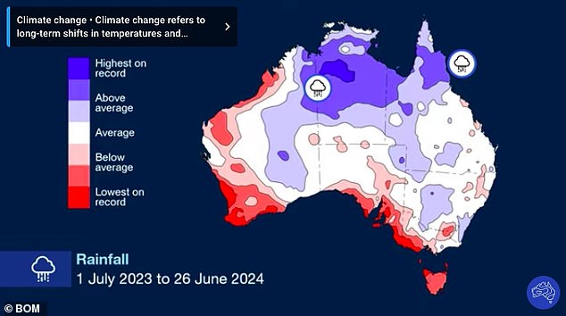
Heavy rain forecast to drench large parts of the country this week could be the start of a wetter-than-average winter and spring for most Australians.
A giant rainband stretching almost 5,000km across the country will soak all areas south of Geraldton in Western Australia and Brisbane in Queensland.
Large pastoral areas in western WA, SA and the Murray-Darling Basin - which covers more than one million square kilometres in Australia's southeast - will receive falls of up to 25mm this week before the rainband shifts east.
Up to 50mm of rain will fall on Sunday and Monday on outback regions in Australia's east, including northern NSW and southern Queensland.
The soaking is expected to exceed the area's average rainfall for an entire winter.
Meanwhile, another rainband will spread across WA on Tuesday and Wednesday, bringing strong winds, showers and cold temperatures.
Up to 50mm of rain is expected to fall across 400km from Perth to Wapole.
The rainband will then travel to Australia's southeast where widespread falls of up to 30mm will soak southwest Victoria and southern SA.

Heavy rain forecast to drench large parts of the country this week could be the start of a wetter-than-average winter and spring for most Australians (people in Adelaide are pictured)
It comes as a long-range forecast by the Bureau of Meteorology revealed above-average rainfall was likely for large parts of eastern and central Australia, including pastoral areas in SA and parts of the east coast, from July to September.
The forecast also predicts rainfall is likely to be within the typical seasonal range for most of northern Australia, Western Australia and Victoria.
'Storms are still common in parts of southern Australia at this time of year, bringing a risk of flooding at times of heavy rainfall - especially in areas where soil is already saturated,' Climatology specialist Caitlin Minney said.
In July, below-average rainfall is likely for western Tasmania and isolated parts of the far south-eastern mainland.
Warmer-than-average days are very likely across northern, eastern and southern Australia, and warmer-than-average nights are very likely across all of Australia.
Above average rainfall is likely for eastern and central Australia from July to September
'While cold fronts and other weather events can still bring cool conditions, the long-range forecast continues to show an increased chance of unusually high temperatures for July to September,' Ms Minney said.
'All of the country has an increased chance of above average temperatures.'
In weather this week, a trough and a cold front will bring icy winds and showers to the southwestern WA coast all the way to the Pilbara.
The system is expected to cross on Tuesday, bringing cool temperatures this week.
In Sydney, rain of up to 10mm on Tuesday is expected to clear by Wednesday when temperatures will reach a maximum of 19C.
Clouds will return on Thursday with the potential for showers to return on Saturday.
Brisbane will receive some wet-and-wild weather at the start of the week before skies clear on Wednesday with temperatures to reach a maximum of 25C.
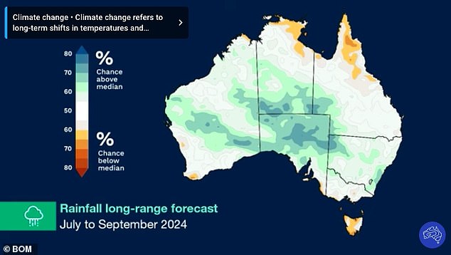
Rainfall will be typical for northern Australia, Western Australia and Victoria this Spring
In Darwin, skies will remain clear and blue with a maximum of 32C this week.
Further south, the ACT will shiver through a cold and wet week filled with showers, icy winds, patches of frost and freezing temperatures.
In Hobart, heavy rain across western and eastern parts of the island state could exceed 50mm this week with temperatures to remain below 15C.
Dry areas in southern SA will receive some light showers at the start of the week before a cold front and associated rainband delivers between 10mm and 30mm to the same areas towards the end of the week.
In Victoria, the same cold front will bring showers to western parts of the state with Tuesday expected to receive the heaviest showers in Melbourne this week.