


US Virgin Islands and Puerto Rico are among Caribbean islands put under tropical storm warning amid fears tempest called Fred could bring up to six inches of rain and cause flash flooding as well as mudslides
- A weather disturbance nearing the Lesser Antilles may become tropical storm
- Tropical storm 'Fred' is likely to bring heavy rain and gusty winds to the Caribbean, regardless of development
- Tropical storm watches are in effect in Martinique, Guadeloupe, Dominica, Saba and St. Eustatius, and a portion of the north coast of Hispaniola
- Locally heavy rain and gusty winds will then move across Puerto Rico and the Virgin Islands Tuesday and the Dominican Republic and Haiti on Wednesday
- Dry air, land interaction and possibly increased wind shear could all be factors to determine the storm's direction of Haiti Cuba and Florida, later this week
Tropical storm warnings were issued for multiple Caribbean islands Monday evening amid fears the tempest - set to be named Fred - could bring flooding and mudslides.
Watches for the U.S. Virgin Islands, Puerto Rico, Culebra, and Vieques have been upgraded to a tropical storm warning, according to an 11pm advisory from the National Hurricane Center.
That means the areas under the warning could be within 36 hours of being hit by the storm.
A watch is in effect for Martinique and Guadeloupe, Dominica, Saba and St. Eustatius, Dominican Republic on the north coast from Cabo Frances Viejo to the Dominican Republic/Haiti border and Haiti from the northern border with the Dominican Republic to Gonaives.
Forecasters believe the disturbance heading toward the Lesser Antilles could become Tropical Storm Fred later on Monday night or early Tuesday morning. It has been more than a month since this year's fifth named storm - Hurricane Elsa - formed.
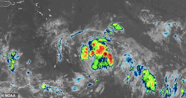
A weather disturbance in the Windward Islands (Saint Lucia, Saint Vincent and the Grenadines, Grenada, Dominica and Martinique) is currently being monitored for development into a tropical storm
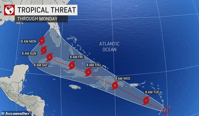
The grey-shaded area denotes the potential path of the center of the storm. It's important to note that impacts with any tropical storm usually spread beyond its forecast path
The disturbance had maximum sustained winds of 35 mph with higher gusts and was 40 miles east-southeast of Dominica, according to officials. A tropical storm has maximum sustained winds between 39mph and 73mph. Storms with winds of 74mph and up are classed as hurricanes. It was moving west-northwest at 15 mph.
The storm is forecast to move through a portion of the southern Leeward Islands Monday night, pass near or over the U.S. Virgin Islands and Puerto Rico late Tuesday and Tuesday night, and near or over Hispaniola on Wednesday.
The storm is expected to produce rainfall totals of 2 to 4 inches (5 to 10 centimeters) over the Leeward Islands, Virgin Islands, and Puerto Rico, with up to 6 inches (15 centimeters) in some areas. The rainfall could lead to flash, urban, and small-stream flooding and potential mudslides across the U.S. Virgin Islands and Puerto Rico.
Potential tropical storm 'Fred' is projected to hit the lesser Antilles before working its way up to Puerto Rico on Wednesday and eastern Cuba on Thursday before potentially making an impact on Florida later this weekend
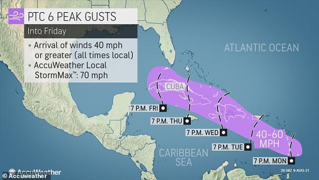
The storm is also expected to bring wind gusts of 40-50 mph into early Tuesday as it crosses the Lesser Antilles.
Since wind shear at mid-levels of the atmosphere and steering breezes near the surface of the ocean may change during the second half of the week, the exact track and strength of the storm is less certain after that point.
Weak storms have demonstrated to shift more to the west in the past, while a well-organized tropical storm may tend to turn more to the northwest over time.
As the system, likely as a tropical storm, passes near or over Hispaniola and Cuba, some the greatest impacts are anticipated in the Caribbean.
The 2021 Atlantic hurricane season continues to run well ahead of the average pace in terms of named tropical storms with a total of five thus far.
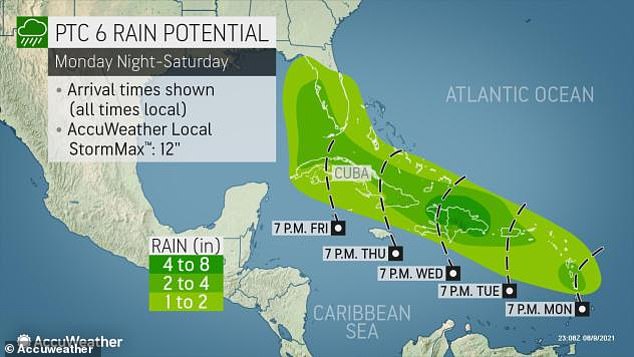
Up to 8inches of rain could fall in these areas, triggering localized flash flooding and mudslides as the storm heads closer to the US
The 2021 Atlantic hurricane season seems to have started earlier than expect with a total of five thus far
Typically, the fifth tropical storm does not occur until the end of August and the first hurricane does not occur until Aug. 10. However, Elsa became the first hurricane of the Atlantic on July 2, more than a month ahead of average.
Elsa took a similar track through the Caribbean before eyeing the U.S., but it was slightly farther south than the path currently projected for the developing tropical system.
Elsa brought drenching showers, thunderstorms and locally gusty winds to part of the Florida Peninsula before making landfall north of Tampa, Florida, during the morning of July 7.
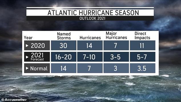
For a time, the 2021 hurricane season was going neck and neck with the record-breaking 2020 season, which spawned 30 named systems and 11 hurricanes.
Most watched News videos
- CCTV footage shows police 'kicking and punching' 16-year-old boy
- Footage shows moment Ukrainian soldiers ambush Russian military truck
- Scene at Bangkok airport where worker crushed to death by lift
- Freddie Flintoff opens up about anxiety of leaving house after crash
- Freddie Flintoff's horrific injuries after Top Gear crash revealed
- Ukraine says its army controls 74 settlements in Russia's Kursk
- Prince Harry and Meghan Markle's chief of staff during Nigeria trip
- Moment motorcycle robbery crew gets instant karma in Brazil
- Russian POWs 'captured during cross-border raid into Kursk'
- Joe Rogan mocks Prince Harry in new Netflix stand up show
- 'War is coming home to Russia' President Zelensky declares online
- Inside shipping container: Sustainable housing site tour in London